长江中下游水系图_鄱阳湖水利枢纽所在地.png

Size of this preview:
800 × 562 pixels
.
Other resolutions:
320 × 225 pixels
|
640 × 449 pixels
|
812 × 570 pixels
.
Summary
| Description |
中文:
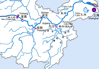
长江中下游水系图,鄱阳湖水利枢纽所在地
English:
Midstream and Downstream Drainage Map of Yangtze River, Poayang Lake Dam's Location
|
| Date | 10:24:33(UTC) |
| Source | |
| Author |
|
|
Permission
( Reusing this file ) |
庐山里人 根据作者 Cncs 绘制的长江水系地图 [1] 改编而成。 |
| Other versions | 根据 GNU自由文件许可协议 ,在版权允许的情况下改编而成,符合版权要求。 |
|
|
This is a
retouched picture
, which means that it has been digitally altered from its original version. Modifications:
Poyang Lake Basin Comprehensive Chart in Chinese and the Dam's Loction
. The original can be viewed here:
Map of the Yangtze River.gif
:
|
= Licensing
I, the copyright holder of this work, hereby publish it under the following license:
This file is licensed under the
Creative Commons
Attribution-Share Alike 3.0 Unported
license.
-
You are free:
- to share – to copy, distribute and transmit the work
- to remix – to adapt the work
-
Under the following conditions:
- attribution – You must give appropriate credit, provide a link to the license, and indicate if changes were made. You may do so in any reasonable manner, but not in any way that suggests the licensor endorses you or your use.
- share alike – If you remix, transform, or build upon the material, you must distribute your contributions under the same or compatible license as the original.
![[1]](https://zh.wikipedia.org/wiki/File:Map_of_the_Yangtze_River.gif)