World_in_2000_BC.svg

Size of this PNG preview of this SVG file:
800 × 397 pixels
.
Other resolutions:
320 × 159 pixels
|
640 × 318 pixels
|
1,024 × 508 pixels
|
1,280 × 635 pixels
|
2,560 × 1,271 pixels
|
4,500 × 2,234 pixels
.
Edit it
Summary
| Description |
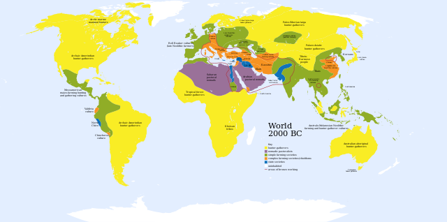
English:
A map of the world, circa
2000 BC
Ελληνικά:
Πολιτισμοί το 2000 π.Χ.
Français :
Une carte du monde aux environs de 2000 av. J.-C.
|
| Date | |
| Source | Based on Image:World_2000_BCE.png by User:Briangotts |
| Author | User:Mr.absurd |
| Other versions |
 in Greek
|
| SVG development |
This diagram was created with
Inkscape
.
This diagram is
translated using SVG
switch
elements
: all translations are stored in the same file.
|
| Maps of world history | |
| BC | |
|
|
|
| AD |
1 · 50 · 100 · 200 · 250 · 300 · 400 · 500 · 700 · 750 · 820 · 900 · 1200 · 1500 · 1556 · 1648 · 1700 · 1750 · 1815 · 1859 · 1871 · 1914 · 1935 · 1954 · 1989 · 2000 · |
|
Maps of colonization history
|
|
|
see also:
Eastern Hemisphere only maps template
(1300BC-1500AD)
|
|
| (this template: · view · discuss ) | |
.jpg)
._LOC_2001620596.jpg)
Key
uninhabited
- Red outline indicates areas of bronze working, c. 2000 BCE.
Licensing
|
|
I, the copyright holder of this work, release this work into the
public domain
. This applies worldwide.
In some countries this may not be legally possible; if so: I grant anyone the right to use this work for any purpose , without any conditions, unless such conditions are required by law. |