Wien_-_Palmenhaus_Schönbrunn_(a).JPG

Size of this preview:
800 × 540 pixels
.
Other resolutions:
320 × 216 pixels
|
640 × 432 pixels
|
1,024 × 692 pixels
|
1,280 × 865 pixels
|
2,560 × 1,729 pixels
|
3,640 × 2,459 pixels
.
Summary
| Description |
Deutsch:
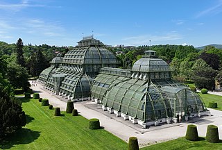
Nordostansicht des Palmenhauses im Schönbrunner Schlosspark im 13. Wiener Gemeindebezirk
Hietzing
.
Das Große Palmenhaus wurde 1880 bis 1882 im Auftrag von Kaiser Franz Joseph I. nach Plänen von Hofarchitekt Franz Xaver Segenschmid von der Firma „Ignaz Gridl, K.u.k. Hof-Eisenconstructions-Werkstätte, Brückenbau-Anstalt und Schlosserei“ errichtet. Mit einer Gesamtfläche von 2.500m² sowie einer Glasfläche von 4.900 m² war die Eisenkonstruktion mit doppelten Glaswänden zum Zeitpunkt der Eröffnung am 19. Juli 1882 das größte Glashaus der Welt. Das aus vorgefertigten Teilen zusammengesetzte Gebäude ist 111 Meter lang, maximal 28 Meter breit und erreicht an der höchsten Stelle 25 Meter. Es ist in drei Klimazonen unterteilt; im südlichen Warmhaus beträgt die Mindesttemperatur 18°C, in der Mittelhalle, dem temperierten Haus, 12°C und im nördlichen Kalthaus 5°C: [1] , [2] .
English:
Northeast view of the Palm House in the park at Schönbrunn Palace.
|
| Date | |
| Source | Own work |
| Author | C.Stadler/Bwag |
|
Permission
( Reusing this file ) |
Deutsch:
Hallo, du darfst mein Foto kostenlos nutzen, aber nenne mich bitte als Fotograf, beispielsweise
„Foto: C.Stadler/Bwag“
oder
© C.Stadler/Bwag; CC-BY-SA-4.0
. Auf mehr Angaben bestehe ich nicht - im Gegensatz zu manch anderen, die die Vorgaben der unten angeführten Lizenzierung auf Punkt und Beistrich einfordern.
English: Feel free to use my photos, but please mention me as the author like © C.Stadler/Bwag or © C.Stadler/Bwag; CC-BY-SA-4.0 (that's good enough) and if you want send me a message: [email protected] . |
| Other versions |
|
.JPG)
| Object location |
|
View this and other nearby images on: OpenStreetMap |
|
|---|
.JPG¶ms=048.184220_N_0016.302910_E_globe:Earth_class:object_type:object__&language=en)
| Camera location |
|
View this and other nearby images on: OpenStreetMap |
|
|---|
.JPG¶ms=048.184920_N_0016.303920_E_globe:Earth_type:camera_heading:240.00&language=en)
Licensing
I, the copyright holder of this work, hereby publish it under the following license:
This file is licensed under the
Creative Commons
Attribution-Share Alike 4.0 International
license.
-
You are free:
- to share – to copy, distribute and transmit the work
- to remix – to adapt the work
-
Under the following conditions:
- attribution – You must give appropriate credit, provide a link to the license, and indicate if changes were made. You may do so in any reasonable manner, but not in any way that suggests the licensor endorses you or your use.
- share alike – If you remix, transform, or build upon the material, you must distribute your contributions under the same or compatible license as the original.