Western_al-Bab_offensive_(2016)_(within_Northern_Syria).svg

Size of this PNG preview of this SVG file:
800 × 555 pixels
.
Other resolutions:
320 × 222 pixels
|
640 × 444 pixels
|
1,024 × 710 pixels
|
1,280 × 888 pixels
|
2,560 × 1,775 pixels
|
3,317 × 2,300 pixels
.
Summary
| Description |
English:
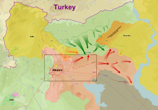
Map of the Western al-Bab offensive (2016). Broken green line shows Opposition frontline prior to offensive. Orange broken line shows the SDF-Opposition frontline in February 2016.
Syrian Armed Forces & Allied Groups
Syrian Democratic Forces
Islamic State of Iraq and the Levant
Free Syrian Army
Northern Aleppo: FSA groups and Turkish troops in Northern Syria
|
| Date | |
| Source |
Own work from Source :
Snaps (via stackoverflow trick) :
|
| Author | MrPenguin20 |
| Other versions | File:Western al-Bab offensive (2016) (within Northern Syria).svg.png |
| SVG development |
|
_(within_Northern_Syria).svg.png)
Licensing
| Description |
This map was created from
OpenStreetMap
project data, collected by the community.
This map may be incomplete, and may contain errors. Don't rely solely on it for navigation.
|
|||
| Date | (see file history) | |||
| Source | openstreetmap.org | |||
| Creator |
OpenStreetMap contributors
|
|||
|
Permission
( Reusing this file ) |
OpenStreetMap data is available under the Open Database License ( details ). Map tiles are licensed under the Creative Commons Attribution-ShareAlike 2.0 license (CC-BY-SA 2.0).
This file is licensed under the
Creative Commons
Attribution-Share Alike 2.0 Generic
license.
|
|||
| Georeferencing | If inappropriate please set warp_status = skip to hide. |