Western_Aleutians.png

Size of this preview:
800 × 463 pixels
.
Other resolutions:
320 × 185 pixels
|
826 × 478 pixels
.
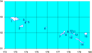
Map of the Western Aleutian Islands. Prepared from Digital Chart of the World (DCW) data. Latitudes are North, longitudes are East. The 52nd parallel is to scale.
1-5 - Near Islands
1 - Attu Island
2 - Agattu Island
3-5 - Semichi Islands
3 - Alaid Island
4 - Nizki Island
5 - Shemya Island
6 - Buldir Island
7-15 Rat Islands
7 - Kiska Island
8 - Little Kiska Island
9 - Segula Island
10 - Khvostof Island
11 - Davidof Island
12 - Little Sitkin Island
13 - Rat Island
14 - Amchitka Island
15 - Semisopochnoi Island
日本語:
1-5 ニア諸島
1 - アッツ島
2 - アガッツ島
3-5 - セミチ諸島
3 - アライド島
4 - ニズキ島
5 - シェムリャ島
6 - ブルダー島
7-15 ラット諸島
7 - キスカ島
8 - 小キスカ島
9 - セグラ島
10 - クヴォストフ島
11 - ダヴィドフ島
12 - 小スィッキン島
13 - ラット島
14 - アムチトカ島
|
|
I, the copyright holder of this work, release this work into the
public domain
. This applies worldwide.
In some countries this may not be legally possible; if so: I grant anyone the right to use this work for any purpose , without any conditions, unless such conditions are required by law. |