West_coast_wildfires_ESA22200484.jpeg

Size of this preview:
413 × 600 pixels
.
Other resolutions:
165 × 240 pixels
|
330 × 480 pixels
|
529 × 768 pixels
|
705 × 1,024 pixels
|
1,410 × 2,048 pixels
|
4,665 × 6,774 pixels
.
Summary
| Description |
English:
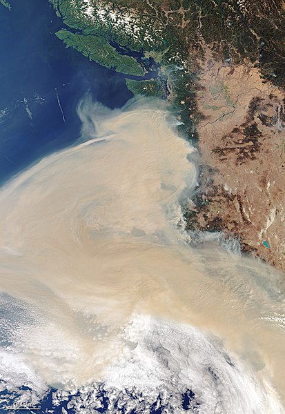
Western US states have been battling close to 100 wildfires, blanketing the majority of the west coast in smoke. Captured on 10 September, this Copernicus Sentinel-3 image shows the extent of the smoke plume which, in some areas, has caused the sky to turn orange.
In this image, multiple fires can be seen in the states of California, Washington and Oregon – the areas hit hardest by the blazes – producing the thick plume of smoke which can be seen travelling westwards. Based on additional data from the Copernicus Sentinel-3 mission, as of yesterday, the smoke was visible travelling 2000 km west of the active fires. The urban regions of Portland, Eureka, Eugene, the San Francisco Bay Area and Sacramento are all blanked in smoke. In the top of the image, the cities of Vancouver and Seattle are visible. Sentinel-3 is a two-satellite mission to supply the coverage and data delivery needed for Europe’s Copernicus environmental monitoring programme. Each satellite’s instrument package includes an optical sensor to monitor changes in the colour of Earth’s surfaces. It can be used, for example, to monitor ocean biology and water quality. |
| Date | 11 September 2020 (upload date) |
| Source | West coast wildfires |
| Author | European Space Agency |
| Activity | Observing the Earth |
| Mission | Sentinel-3 |
| System | Copernicus |
Licensing

|
This image contains data from a satellite in the
Copernicus Programme
, such as
Sentinel-1
,
Sentinel-2
or
Sentinel-3
. Attribution is required when using this image.
Attribution:
Contains modified Copernicus Sentinel data 2020
The use of Copernicus Sentinel Data is regulated under EU law ( Commission Delegated Regulation (EU) No 1159/2013 and Regulation (EU) No 377/2014 ). Relevant excerpts:
Free access shall be given to GMES dedicated data [...] made available through GMES dissemination platforms [...].
Access to GMES dedicated data [...] shall be given for the purpose of the following use in so far as it is lawful:
GMES dedicated data [...] may be used worldwide without limitations in time.
GMES dedicated data and GMES service information are provided to users without any express or implied warranty, including as regards quality and suitability for any purpose. |
|
|
This media was created by the
European Space Agency
(ESA).
Where expressly so stated , images or videos are covered by the Creative Commons Attribution-ShareAlike 3.0 IGO (CC BY-SA 3.0 IGO) licence, ESA being an Intergovernmental Organisation (IGO), as defined by the CC BY-SA 3.0 IGO licence. The user is allowed under the terms and conditions of the CC BY-SA 3.0 IGO license to Reproduce, Distribute and Publicly Perform the ESA images and videos released under CC BY-SA 3.0 IGO licence and the Adaptations thereof, without further explicit permission being necessary, for as long as the user complies with the conditions and restrictions set forth in the CC BY-SA 3.0 IGO licence, these including that:
See
the ESA Creative Commons copyright notice
for complete information, and
this article
for additional details.
|

|
|
This file is licensed under the
Creative Commons
Attribution-ShareAlike 3.0 IGO
license.
Attribution:
ESA,
CC BY-SA IGO 3.0
|
||