Uruguay_T2.png

Size of this preview:
527 × 599 pixels
.
Other resolutions:
211 × 240 pixels
|
422 × 480 pixels
|
691 × 786 pixels
.
Summary
| Description |
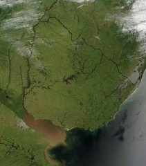
Español:
Foto de
Uruguay
tomada desde satélite. Se aprecian claramente los límites con
Brasil
y
Argentina
, y el
Río de la Plata
al sur.
English:
Photo of
Uruguay
taken from satellite, where the limits with
Brazil
and
Argentina
are clearly appreciated, as well as the
Río de la Plata
to the south.
|
| Date | |
| Source | http://visibleearth.nasa.gov/view_rec.php?id=4817 |
| Author | Jeff Schmaltz, MODIS Rapid Response Team, NASA/GSFC |
Licensing
|
|
This file is in the public domain in the United States because it was solely created by NASA . NASA copyright policy states that "NASA material is not protected by copyright unless noted ". (See Template:PD-USGov , NASA copyright policy page or JPL Image Use Policy .) |
|

|
Warnings:
|