Urchfont_Manor_(2)_-_geograph.org.uk_-_1403245.jpg
No higher resolution available.
Summary
| Description |
English:
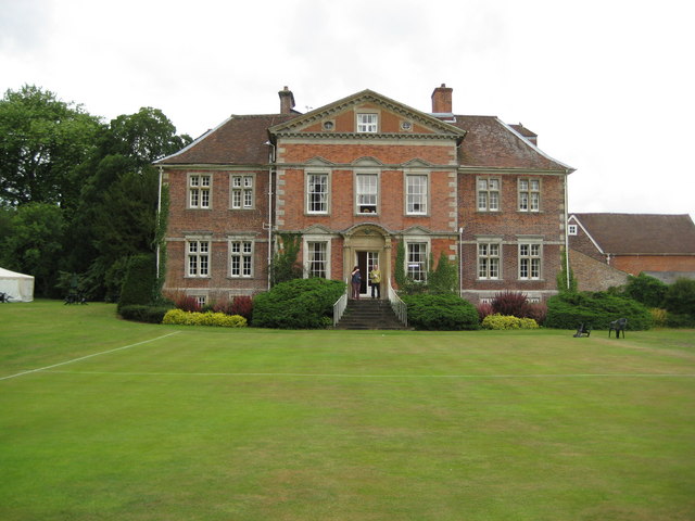
Urchfont Manor (2). This is the east façade of the manor house, whose history is briefly told here
1403212
This side of the building, although built only about nine years after the original house, is markedly different, its seven bays with a pediment over the three central ones in the then very modern Wren or Queen Anne style being designed to create the impression that the house was much larger than it really was. The rear of the north end of this extension can be seen in the other image and demonstres the difference between the two parts of the building.
The manicured lawn in front is a croquet pitch.
|
| Date | |
| Source | From geograph.org.uk |
| Author | Nigel Cox |
|
Attribution
( required by the license ) |
Nigel Cox / Urchfont Manor (2) / |
_-_geograph.org.uk_-_1403212.jpg)
| Camera location |
|
View this and other nearby images on: OpenStreetMap |
|
|---|
_-_geograph.org.uk_-_1403245.jpg¶ms=051.311970_N_-001.949200_E_globe:Earth_type:camera_source:geograph-osgb36(SU03635698)_heading:247.00&language=en)
| Object location |
|
View this and other nearby images on: OpenStreetMap |
|
|---|
_-_geograph.org.uk_-_1403245.jpg¶ms=051.311880_N_-001.949800_E_globe:Earth_class:object_type:object_source:geograph-osgb36(SU03595697)_heading:247.00&language=en)
Licensing

|
This image was taken from the
Geograph project
collection. See
this photograph's page
on the Geograph website for the photographer's contact details. The copyright on this image is owned by
Nigel Cox
and is licensed for reuse under the
Creative Commons
Attribution-ShareAlike 2.0 license.
|
This file is licensed under the
Creative Commons
Attribution-Share Alike 2.0 Generic
license.
Attribution:
Nigel Cox
-
You are free:
- to share – to copy, distribute and transmit the work
- to remix – to adapt the work
-
Under the following conditions:
- attribution – You must give appropriate credit, provide a link to the license, and indicate if changes were made. You may do so in any reasonable manner, but not in any way that suggests the licensor endorses you or your use.
- share alike – If you remix, transform, or build upon the material, you must distribute your contributions under the same or compatible license as the original.