USACE_Glover_Wilkins_Lock_and_Dam.jpg

Size of this preview:
800 × 560 pixels
.
Other resolutions:
320 × 224 pixels
|
640 × 448 pixels
|
1,024 × 717 pixels
|
1,280 × 896 pixels
|
1,500 × 1,050 pixels
.
| Description |
English:
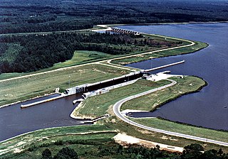
Aerial view of Glover Wilkins Lock and Dam on the Tombigbee River near Smithville, Monroe County, Mississippi, USA. The lock and river are part of the Tennessee-Tombigbee Waterway, connecting the Tennessee River to the Gulf of Mexico. The U.S. Army Corps of Engineers maintains the lock and waterway for barge navigation. View is upriver to the north.
Coordinates:
34°3′53.54″N
88°25′33.19″W
/
34.0648722°N 88.4258861°W
|
|||
| Location | Smithville, Monroe County, Mississippi, USA | |||
| Date | ||||
| Source |
U.S. Army Corps of Engineers Digital Visual Library
Image page Image description page Digital Visual Library home page |
|||
| Author | Adrien Lamarre, U.S. Army Corps of Engineers | |||
|
Permission
( Reusing this file ) |
|