Tunisia_Antica.jpg

Size of this preview:
399 × 600 pixels
.
Other resolutions:
159 × 240 pixels
|
479 × 720 pixels
.
| Description |
English:
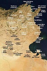
Satellite map of Tunisia, with ancient Punic and Roman archeological sites. White dot : important archeological sites. Red dot : other antic site. Personal work.
Français :
Carte satellite de la Tunisie, avec d'anciens sites archéologiques puniques et romains. Point blanc: sites archéologiques importants. Point rouge: autre site antique. Travail personnel.
|
| Date |
English:
Satellite image from August 2001, derivative work from 15 September 2008 (original upload date)
|
| Source | Image:Satellite image of Tunisia in August 2001.jpg [1] |
| Author | NASA's Visible Earth, derivative work by Ursus |
|
Permission
( Reusing this file ) |
Sattelite image: PD-USGov-NASA, derivative work: PD-self |
| Other versions | Original , العربيَّة |
|
|
This work has been released into the
public domain
by its author,
Ursus
. This applies worldwide.
In some countries this may not be legally possible; if so:
|
|
|
This file is in the public domain in the United States because it was solely created by NASA . NASA copyright policy states that "NASA material is not protected by copyright unless noted ". (See Template:PD-USGov , NASA copyright policy page or JPL Image Use Policy .) |
|

|
Warnings:
|

|
This
map
image could be re-created
using
vector graphics
as an
SVG
file
. This has several advantages; see
Commons:Media for cleanup
for more information. If an SVG form of this image is available, please upload it and afterwards replace this template with
{{

vector version available

|

new image name

}}
.
It is recommended to name the SVG file “Tunisia Antica.svg”—then the template Vector version available (or Vva ) does not need the new image name parameter. |

