Tsurai_Plaque.JPG

Size of this preview:
800 × 600 pixels
.
Other resolutions:
320 × 240 pixels
|
640 × 480 pixels
|
1,024 × 768 pixels
|
1,280 × 960 pixels
|
2,560 × 1,920 pixels
|
4,000 × 3,000 pixels
.
Summary
| Description |
English:
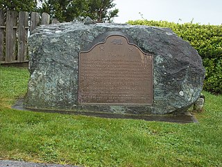
California Registered Historical Landmark No. 838: Old Indian village of Tsurai.
Located in Trinidad, California this stone marker and plaque mark the former location of the indigenous Yurok settlement of
Tsurai
.
|
||
| Date | |||
| Source | Own work | ||
| Author | Nytasi | ||
|
Permission
( Reusing this file ) |
|
| Camera location |
|
View this and other nearby images on: OpenStreetMap |
|
|---|
Transcription
|
TSURAI
DIRECTLY BELOW WAS LOCATED THE ANCIENT YUROK VILLAGE OF TSURAI . A PREHISTORIC, PERMANENT INDIAN COMMUNITY, IT WAS FIRST LOCATED AND DESCRIBED BY CAPTAINS BODEGA AND HECETA , JUNE 9-19, 1775. THE HOUSES WERE OF HAND-SPLIT REDWOOD PLANKS, DESIGNED FOR DEFENSE AND PRO- TECTION. THE VILLAGE WAS OCCUPIED UNTIL 1916. CALIFORNIA REGISTERED HISTORICAL LANDMARK NO. 838 PLAQUE PLACED BY THE STATE DEPARTMENT OF PARKS AND RECREATION IN COOPERATION WITH HERITAGE TRINIDAD AND THE HUMBOLDT COUNTY HISTORICAL SOCIETY, JULY 22, 1970. |
Licensing
I, the copyright holder of this work, hereby publish it under the following license:
|
|
This file is made available under the Creative Commons CC0 1.0 Universal Public Domain Dedication . |
|
The person who associated a work with this deed has dedicated the work to the
public domain
by waiving all of their rights to the work worldwide under copyright law, including all related and neighboring rights, to the extent allowed by law. You can copy, modify, distribute and perform the work, even for commercial purposes, all without asking permission.
|