|
Description
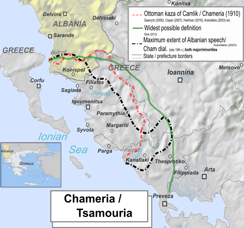
Tsamouria.Chameria.png
|
Ελληνικά:
Χάρτης που απεικονίζει τους διάφορους γεωγραφικούς ορισμούς της Τσαμουριάς και την απώτερη διείσδυση αλβανοφωνίας στην Ήπειρο την Ύστερη Οθωμανική Περίοδο
English:
Map showing the various boundaries of Chameria/Tsamouria and the maximum extent of Albanian speech in late Ottoman Epirus
Українська:
На мапі зображено різні межі регіону Чамерія і максимального поширення албанської мови в Османському Епірі
|
|
Source
|
Map based on work:
-
Albanian speech maximum extent line from: Kokolakis: Το Ύστερο Γιαννιώτικο Πασαλίκι, 2003,
ISBN
960-7916-11-5
, p. 374
-
Kaza of Camlik/Chameria/Tsamouria from:
-
Kokolakis, "η ενοποίηση της Τσαμουριάς σε κοινό σαντζάκι (1910)", p. 94, "«σαντζακι της Τσαμουριάς» από τη γεωγραφική περιοχή που κάλυπτε.. Και εδώ αποσπάστηκαν από τα αρχικά τους σαντζάκια τρεις παλιοί καζάδες (Φιλιατών και Παραμυθιάς από τα Γιάννενα, Μαργαριτιού από την Πρέβεζα), και από το έδαφος του τελευταίου δημιουργήθηκε ένας νέος κεντρικός καζάς, στον οποίο εγκαταστάθηκε η έδρα του μουτεσαρίφη", p. 160-616,
-
Hartman E., Die Reichweite des Staates: Wehrpflicht und moderne Staatlichkeit im Osmanischen Reich 1869-1910
ISBN
9783657783731
, p. 118: "Die kazas Filat, Aydonat, Margiliç und die Stadt Parga bildeten seit 1909 einen eigenen sancak Çamlak."
-
(in French)
Aux origines du nationalisme albanais.: La naissance d'une nation majoritairement musulmane en Europe
, KARTHALA Editions, p. 104
ISBN
:
978-2-8111-2535-6
.
"Ils créèrentun sandjak de Çamlık, c'est-à-dire de Çamëri, parla réunion du kaza de Margariti, appartenant au sandjak de Preveza, aux kaza de Aydonat/Paramithia et filat/filiates"
-
Description is rouphly identical with "Chameria / Tsamouria", sources:
-
Gawrych, George (2006)
The Crescent and the Eagle: Ottoman rule, Islam and the Albanians, 1874–1913
,
London
: IB Tauris, pp. 23
ISBN
:
9781845112875
.
"According to the Ottoman administrative system of the 1880s, ... Toskalık also divided into three parts, Toskalık, Laplık and Çamlık... Chamland (Çamlık) encompassed Margalic, Aydonat, and Filat."
-
(
1 January 1986
). "
The moslems of Chamuria and the exchange of populations between Greece and Turkey
".
Balkan Studies
27
(2): 303–313.
ISSN
2241-1674
.
-
E. Manta,
Ματιές στην Ιστορία: Τσάμηδες και Tσαμουριά
: "Τσαμουριά ονομάζεται η περιοχή εκείνη της Ηπείρου, που εκτείνεται κατά μήκος της ακτής ανάμεσα στις εκβολές του ποταμού Αχέροντα και μέχρι το Βουθρωτό και ανατολικά μέχρι τους πρόποδες του όρους Ολύτσικας (Τόμαρος). Η περιοχή ταυτίζεται με τη Θεσπρωτία και ένα μικρό της τμήμα ανήκει σήμερα στην Αλβανία με κέντρο την κωμόπολη Κονίσπολη."
-
Kentriotis Kyriakos,
Der Verlauf der Griechisch-Albanischen Beziehungen nach dem Zweiten WEeltkrieg und die Frage der Muslimischen Tschamen
, Institute for Balkan Studies, p. 19-20: "Çamëria hieß jene Gegend von Epirus, die sich an der Küste entlang zwischen der Mündung des Acheron bis nach Butrint"
-
(2002). "
in an area which today is called Thesprotia in Greek and Chameria in Albanian (as well as in seven villages on the Albanian side of the border).
".
Ethnologia Balkanica
6
: 173. LIT Verlag Münster. Retrieved on
29 June 2017
. "in an area which today is called Thesprotia in Greek and Chameria in Albanian (as well as in seven villages on the Albanian side of the border)."
-
Meyer, Hermann Frank (2008) (in german)
Blutiges Edelweiß: Die 1. Gebirgs-division im zweiten Weltkrieg [Bloodstained Edelweiss. The 1st Mountain-Division in WWII
]
, Ch. Links Verlag, pp. 464
ISBN
:
978-3-86153-447-1
.
"...Prafektur Thesprotia, die sogenannte Tsamouria"
-
Kallivretakis, Leonidas (1995). "
Η ελληνική κοινότητα της Αλβανίας υπό το πρίσμα της ιστορικής γεωγραφίας και δημογραφίας [The Greek Community of Albania in terms of historical geography and demography
." In Nikolakopoulos, Ilias, Kouloubis Theodoros A. & Thanos M. Veremis (eds).
Ο Ελληνισμός της Αλβανίας [The Greeks of Albania]
. University of Athens. p. 36: "διοικητικά η περιοχή δεν ήταν ενιαία, είναι εντούτοις ενδιαφέρον οτι εκκλησιαστικά η περιφέρεια συνέπιπτε σχεδόν εξ ολοκλήρου με την Επισκοπή Παραμυθιάς." [... it rouphly concided with the bishopric of Paramythia].
|