TreatyOfSevres.png

Size of this preview:
800 × 577 pixels
.
Other resolutions:
320 × 231 pixels
|
640 × 461 pixels
|
1,024 × 738 pixels
.
Summary
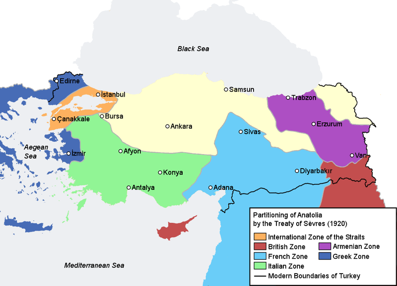
| Description | Map illustrating the partitioning of Anatolia according to the Treaty of Sèvres (1920) after World War I. | ||
| Date | |||
| Source | Self-made, based on Image:Turkey map blank.png and with information compiled from [1] , [2] | ||
| Author | AtilimGunesBaydin | ||
|
Permission
( Reusing this file ) |
|
||
| Other versions | File:Treaty of Sèvres map partitioning Anatolia.png |
![[1]](http://www.let.uu.nl/~martin.vanbruinessen/personal/pictures/Kurdica/09_Treaty_of_Sevres.jpg)
![[2]](http://www.nipissingu.ca/department/history/MUHLBERGER/uploaded_images/Map-color-Treaty-of-Sevres-748832.png)

|
This
historical map
image could be re-created
using
vector graphics
as an
SVG
file
. This has several advantages; see
Commons:Media for cleanup
for more information. If an SVG form of this image is available, please upload it and afterwards replace this template with
{{

vector version available

|

new image name

}}
.
It is recommended to name the SVG file “TreatyOfSevres.svg”—then the template Vector version available (or Vva ) does not need the new image name parameter. |