Torpedoed_Japanese_destroyer_Yamakaze_sinking_on_25_June_1942.jpg

Size of this preview:
759 × 599 pixels
.
Other resolutions:
304 × 240 pixels
|
608 × 480 pixels
|
973 × 768 pixels
|
1,280 × 1,011 pixels
|
2,560 × 2,021 pixels
|
2,937 × 2,319 pixels
.
Summary
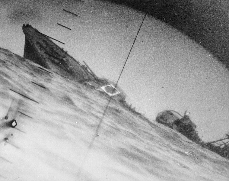
| Description | Sinking of the Japanese destroyer Yamakaze on 25 June 1942 approximately 110 km southeast of Yokosuku , Japan, photographed through the periscope of the U.S. Navy submarine USS Nautilus (SS-168). This position is given in The Official Chronology of the U.S. Navy in World War II by Robert Cressman. NH 111751 says 75 miles southwest of Yokahama Harbor. Yokahama is near Yokosuku. | |||
| Date | ||||
| Source |
|
|||
| Author | U.S. Navy | |||
| Other versions | Official U.S. Navy photo NH 111751 from the U.S. Navy Naval History and Heritage Command |
| Camera location |
|
View this and other nearby images on: OpenStreetMap |
|
|---|
|
Licensing
|
|
This file is a work of a sailor or employee of the
U.S. Navy
, taken or made as part of that person's official duties. As a
work
of the
U.S. federal government
, it is in the
public domain
in the United States.
|

|
| This file has been identified as being free of known restrictions under copyright law, including all related and neighboring rights. | ||