Top_of_Atmosphere.jpg
|
|
|
This image was selected as
picture of the day
on Wikimedia Commons for
22 February 2013
. It was captioned as follows:
English:
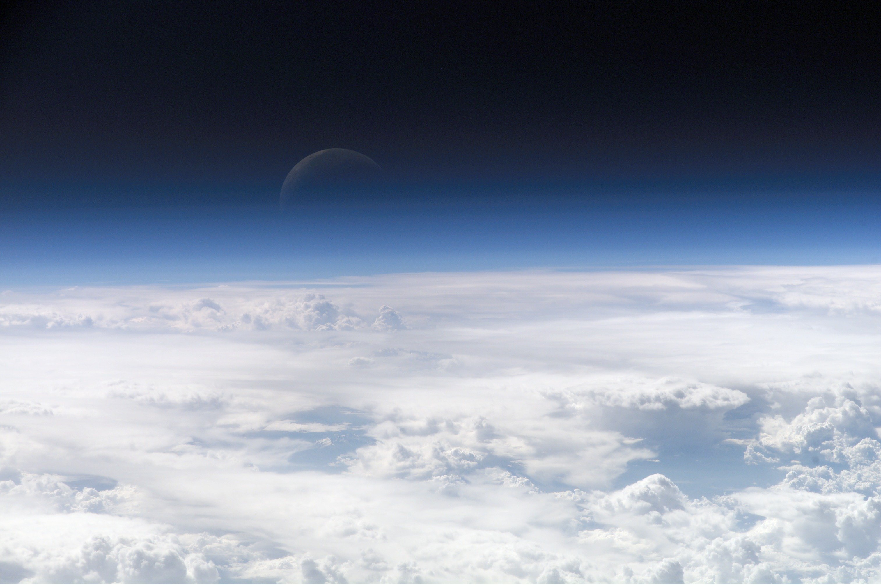
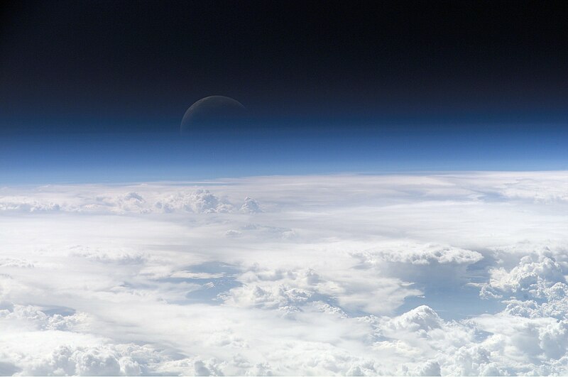
View of the crescent moon through the top of the earth's atmosphere. Photographed from
International Space Station
by
Expedition 13
crew over the
South China Sea
, just south of
Macau
.
Other languages:
Čeština
:
Pohled na srpek Měsíce skrz vršek zemské atmosféry. Vyfoceno posádkou
Mezinárodní vesmírné stanice
v rámci
Expedice 13
nad
Jihočínským mořem
jižně od
Macaa
, 21,5° S, 113,3° V
Deutsch
:
Die oberen Schichten der
Erdatmosphäre
, gesehen von der
Internationalen Raumstation (ISS)
während der
ISS-Expedition 13
English
:
View of the crescent moon through the top of the earth's atmosphere. Photographed from
International Space Station
by
Expedition 13
crew over the
South China Sea
, just south of
Macau
.
Italiano
:
Vista della luna crescente dalla sommità dell'
atmosfera terrestre
. Foto scattata alle coordinate 21.5°N, 113.3°E dall'equipaggio della
Stazione Spaziale Orbitante Internazionale
Expedition 13
sopra il
Mar Cinese Orientale
, appena a sud di
Macau
(NASA image ID: ISS013-E-54329).
Magyar
:
Félholdra táruló kilátás a Föld légkörén keresztül. A fénykép a
Nemzetközi Űrállomás
13-dik expedícióján, a
Dél-kínai-tenger
fölött,
Makaótól
délre készült.
Nederlands
:
Zicht op de maansikkel door de bovenkant van de atmosfeer van de aarde. Gefotografeerd boven 21,5° N, 113,3° E door de bemanning van het
internationaal ruimtestation ISS
tijdens expeditie 13 boven de
Zuid-Chinese Zee
, net ten zuiden van
Macau
.
Polski
:
Widok
Księżyca
z górnych warstw amosfery ziemskiej. Fotografia wykonana przez załogę
Ekspedycji 13
Międzynarodowej Stacji Kosmicznej
nad
Morzem Południowochińskim
, na południe od
Makau
Svenska
:
En
månskära
sedd genom atmosfärens övre lager, fotograferad från
Internationella rymdstationen
ovanför
Sydkinesiska sjön
söder om
Macau
.
ქართული
:
სამხრეთი ჩინეთის ზღვის
თავზე,
მაკაოს
სამხრეთით,
მე-13 ექსპედიციის
მონაწილის მიერ გადაღებული
ნახევარმთვარის
ფოტო
დედამიწის ატმოსფეროს
ზედა ფენებიდან.
中文
:
地球大气层上的
新月
,地理位置为中国南海上空,经纬度21.5°N, 113.3°E,由国际空间站第13远征组成员拍摄。
|
Summary
| Description |
Čeština:
Pohled na srpek Měsíce skrz vršek zemské atmosféry. Vyfoceno posádkou
Mezinárodní vesmírné stanice
v rámci
Expedice 13
nad
Jihočínským mořem
jižně od
Macaa
, 21,5° S, 113,3° V
English:
View of the crescent moon through the top of the Earth's atmosphere. Photographed above 21.5°N, 113.3°E by
International Space Station
crew
Expedition 13
over the
South China Sea
, just south of
Macau
(NASA image ID: ISS013-E-54329).
Français :
Photo des couches hautes de l'atmosphère terrestre, prise par 21.5°N, 113.3°E par la
Station spatiale internationale
au cours de l'
Expédition 13
au-dessus de la
Mer de Chine méridionale
, juste au sud de
Macao
. Numéro d'identification d'image de la NASA : ISS013-E-54329.
Italiano:
Vista della luna crescente dalla sommità dell'atmosfera terrestre. Foto scattata alle coordinate 21.5°N, 113.3°E dall'equipaggio della
Stazione Spaziale Internazionale
Expedition 13
sopra il
Mar Cinese Orientale
, appena a sud di
Macau
(NASA image ID: ISS013-E-54329).
ქართული:
სამხრეთი ჩინეთის ზღვის
თავზე,
მაკაოს
სამხრეთით,
მე-13 ექსპედიციის
მონაწილის მიერ გადაღებული
ნახევარმთვარის
ფოტო დედამიწის ატმოსფეროს ზედა ფენებიდან.
Polski:
Zdjęcie górnych warstw atmosfery ziemskiej z widocznym przejściem w przestrzeń kosmiczną.
Ελληνικά:
Η Γήινη ατμόσφαιρα, η φωτογραφία ελήφθη από το διάστημα κι ύψος 335 χιλιόμετρα
|
| Date | |
| Source | http://eol.jsc.nasa.gov/scripts/sseop/photo.pl?mission=ISS013&roll=E&frame=54329 |
| Author | NASA Earth Observatory |
|
|
This image or video was catalogued by one of the centers of the United States
National Aeronautics and Space Administration
(NASA) under
Photo ID:
ISS013-E-54329
.
This tag does not indicate the copyright status of the attached work. A normal copyright tag is still required. See Commons:Licensing .
Other languages:
|
Licensing
|
|
This file is in the public domain in the United States because it was solely created by NASA . NASA copyright policy states that "NASA material is not protected by copyright unless noted ". (See Template:PD-USGov , NASA copyright policy page or JPL Image Use Policy .) |
|

|
Warnings:
|
Image information
Identification
Top Of The Atmosphere
Mission: ISS013 Roll: E Frame: 54329 Mission ID on the Film or image: ISS013
Country or Geographic Name:
Features: EARTH LIMB, MOON, CLOUD TOPS
Center Point Latitude: Center Point Longitude: (Negative numbers indicate south for latitude and west for longitude)
Stereo: (Yes indicates there is an adjacent picture of the same area)
ONC Map ID: JNC Map ID:
' MORALES'
Camera Tilt: Low Oblique
Camera Focal Length: 400mm
Camera: E4: Kodak DCS760C Electronic Still Camera
Film: 3060E : 3060 x 2036 pixel CCD, RGBG array.
Quality
Film Exposure:
Percentage of Cloud Cover: 100 (76-100)
Nadir
Date: 20060720 (YYYYMMDD)GMT Time: 082858 (HHMMSS)
Nadir Point Latitude: 21.5, Longitude: 113.3 (Negative numbers indicate south for latitude and west for longitude)
Nadir to Photo Center Direction:
Sun Azimuth: 281 (Clockwise angle in degrees from north to the sun measured at the nadir point)
Spacecraft Altitude: 181 nautical miles (335 km)
Sun Elevation Angle: 35 (Angle in degrees between the horizon and the sun, measured at the nadir point)
Orbit Number: 3839