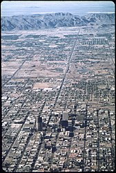
The_View_of_Phoenix's_Urban_Sprawl_from_4000_Ft._South_Mountain_in_Background_,_6_1972.jpg

|
This is a
retouched picture
, which means that it has been digitally altered from its original version. The original can be viewed here:
THE VIEW OF PHOENIX'S URBAN SPRAWL FROM 4000 FT. SOUTH MOUNTAIN IN BACKGROUND - NARA - 544073.jpg
:
|
Summary
|
Cornelius M. Keyes
:
The View of Phoenix's Urban Sprawl from 4000 Ft. South Mountain in Background , 6/1972
|
|||||||||||||||||||||||||||
|---|---|---|---|---|---|---|---|---|---|---|---|---|---|---|---|---|---|---|---|---|---|---|---|---|---|---|---|
| Artist |
|
||||||||||||||||||||||||||
| Author |
Keyes, Cornelius M. (Cornelius Michael), 1944-, Photographer (
NARA record: 8463989
)
|
||||||||||||||||||||||||||
|
Record creator
InfoField
|
Environmental Protection Agency. (12/02/1970 - ) | ||||||||||||||||||||||||||
| Title |
View of
Phoenix's
Urban Sprawl from 4000 Ft.
South Mountain
in Background , 6/1972
|
||||||||||||||||||||||||||
| Object type |
photograph
|
||||||||||||||||||||||||||
| Genre |
documentary photography
|
||||||||||||||||||||||||||
| Description |
English:
:::*
Aerial view
of Phoenix,
Arizona
, in
June 1972
.
|
||||||||||||||||||||||||||
| Depicted place |
Phoenix (Maricopa County, Arizona, United States, North and Central America) inhabited place (
33°25′59″N
112°04′12″W
/
33.433°N 112.07°W
/
33.433; -112.07
;
NARA geographical record
)
|
||||||||||||||||||||||||||
| Date |
June 1972
date QS:P571,+1972-06-00T00:00:00Z/10
|
||||||||||||||||||||||||||
| Publication date |
circa
|
||||||||||||||||||||||||||
| Medium |
photographic emulsion
|
||||||||||||||||||||||||||
| Collection |
institution QS:P195,Q38945047
Still Picture Records Section, Special Media Archives Services Division (NWCS-S)
|
||||||||||||||||||||||||||
| Accession number |
|
||||||||||||||||||||||||||
| Object location |
|
||||||||||||||||||||||||||
| Place of creation |
United States of America
|
||||||||||||||||||||||||||
|
Record ID
InfoField
|
NAIL Control Number: NWDNS-412-DA-1580
|
||||||||||||||||||||||||||
| References | |||||||||||||||||||||||||||
| Source | U.S. National Archives and Records Administration | ||||||||||||||||||||||||||
| Other versions |
Please
do not overwrite
this file:
any restoration work should be uploaded with a new name and linked in this page's "
other versions=
" parameter, so that this file represents the
exact
file found in the NARA catalog record to which it links. The metadata on this page was imported directly from NARA's catalog record; additional descriptive text may be added by Wikimedians to the template below with the "
description=
" parameter, but please do not modify the other fields.
|
||||||||||||||||||||||||||
| Object location |
33° 25′ 58.8″ N, 112° 04′ 12″ W
|
View this and other nearby images on: OpenStreetMap |
|
|---|
Licensing
| Public domain Public domain false false |
|
|
This image (or other media) is a work of an
Environmental Protection Agency
employee, taken or made as part of that person's official duties. As
works
of the
U.S. federal government
, all EPA images are in the
public domain
.
|
|
| العربية ∙ Deutsch ∙ English ∙ eesti ∙ italiano ∙ 日本語 ∙ македонски ∙ Nederlands ∙ polski ∙ português ∙ sicilianu ∙ slovenščina ∙ ไทย ∙ українська ∙ 简体中文 ∙ 繁體中文 ∙ +/− |


