The_Grey_Mare_and_Her_Colts_Long_Barrow._-_geograph.org.uk_-_1123108.jpg
No higher resolution available.
Summary
| Description |
English:
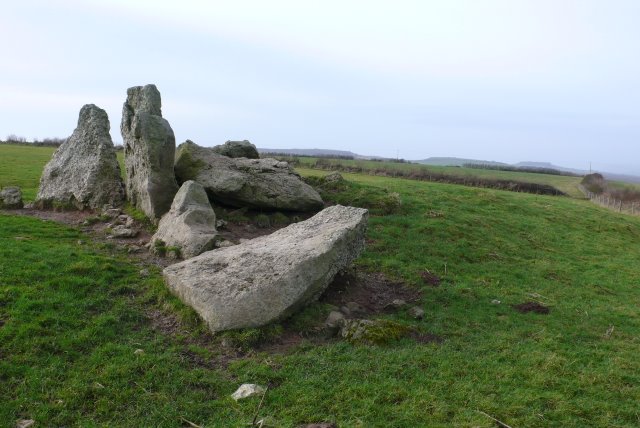
The Grey Mare and Her Colts Long Barrow. This neolithic chambered long barrow located high on the Dorset chalk downs near Kingston Russell is only have a mile away from the stone circle of that name.This is the view from the eastern corner along the length of the barrow which runs SE-NW. The two largest stone form mthepart of the chamber at the SE end.
|
|
| Date | ||
| Source | From geograph.org.uk | |
| Author | Nigel Mykura | |
|
Attribution
( required by the license ) |
Nigel Mykura / The Grey Mare and Her Colts Long Barrow. / | |
| Camera location |
|
View this and other nearby images on: OpenStreetMap |
|
|---|
_heading:292.00&language=en)
| Object location |
|
View this and other nearby images on: OpenStreetMap |
|
|---|
_heading:292.00&language=en)
Licensing

|
This image was taken from the
Geograph project
collection. See
this photograph's page
on the Geograph website for the photographer's contact details. The copyright on this image is owned by
Nigel Mykura
and is licensed for reuse under the
Creative Commons
Attribution-ShareAlike 2.0 license.
|
This file is licensed under the
Creative Commons
Attribution-Share Alike 2.0 Generic
license.
Attribution:
Nigel Mykura
-
You are free:
- to share – to copy, distribute and transmit the work
- to remix – to adapt the work
-
Under the following conditions:
- attribution – You must give appropriate credit, provide a link to the license, and indicate if changes were made. You may do so in any reasonable manner, but not in any way that suggests the licensor endorses you or your use.
- share alike – If you remix, transform, or build upon the material, you must distribute your contributions under the same or compatible license as the original.