The_Amazing_Race_18_map.png

Size of this preview:
800 × 411 pixels
.
Other resolutions:
320 × 164 pixels
|
640 × 329 pixels
|
1,024 × 526 pixels
|
1,280 × 657 pixels
|
2,000 × 1,027 pixels
.
| The Amazing Race maps |
| Original U.S. version |
| Countries visited · US states |
| Route maps |
| Seasons: 1 · 2 · 3 · 4 · 5 · 6 · 7 · 8 · 9 · 10 · 11 · 12 · 13 · 14 · 15 · 16 · 17 · 18 · 19 ( svg ) · 20 ( svg ) · 21 · 22 · 23 · 24 · 25 · 26 · 27 · 28 ˑ 29 ˑ 30 ˑ 31 ˑ 32 ˑ 33 ˑ 34 ˑ 35 ˑ 36 |

|
This
map
image could be re-created
using
vector graphics
as an
SVG
file
. This has several advantages; see
Commons:Media for cleanup
for more information. If an SVG form of this image is available, please upload it and afterwards replace this template with
{{

vector version available

|

new image name

}}
.
It is recommended to name the SVG file “The Amazing Race 18 map.svg”—then the template Vector version available (or Vva ) does not need the new image name parameter. |
Summary
| Description |
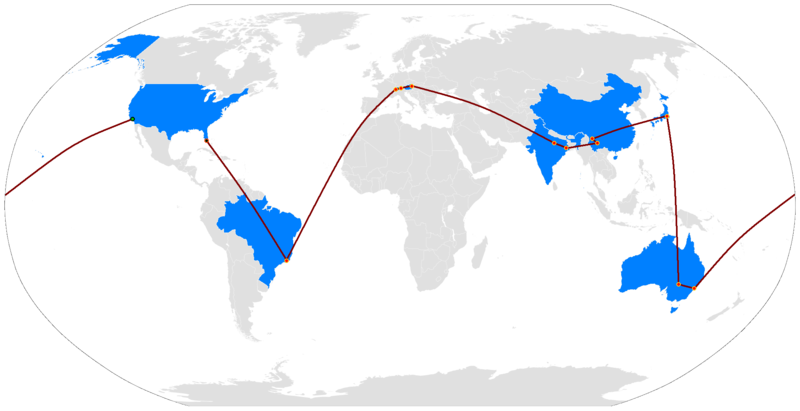
English:
The Route Map of The Amazing Race 18
|
| Date | (UTC) |
| Source | BlankMap-World.png |
| Author | — Ryūlóng ( 竜龍 ) |
| Other versions |

|
Licensing
|
|
I, the copyright holder of this work, release this work into the
public domain
. This applies worldwide.
In some countries this may not be legally possible; if so: I grant anyone the right to use this work for any purpose , without any conditions, unless such conditions are required by law. |