Tharsis_Tholus_block.JPG
No higher resolution available.
Summary
| Description |
English:
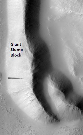
Tharsis Tholus block, as seen by hirise. Location is 13.9 degrees north latitude and 267.8 degrees east longitude. Image was taken by the Mars Reconnaissance Orbiter's HiRISE. The HiRISE camera was built by Ball Aerospace and Technology orporation and is operated by the University of Arizona. Image courtesy NASA/JPL/University of Arizona.
|
| Date | |
| Source | http://hirise.lpl.arizona.edu/PSP_007127_1940 |
| Author | Jim Secosky modified NASA image. |
Licensing
|
|
This file is in the public domain in the United States because it was solely created by NASA . NASA copyright policy states that "NASA material is not protected by copyright unless noted ". (See Template:PD-USGov , NASA copyright policy page or JPL Image Use Policy .) |
|

|
Warnings:
|
Original upload log
Transferred from en.wikipedia to Commons by FrancescoA .
The original description page was
here
. All following user names refer to en.wikipedia.
- 2009-03-02 17:58 Jimmarsmars 284×463× (15915 bytes) {{Information |Description=Tharsis Tholus block, as seen by hirise. Location is 13.9 degrees north latitude and 267.8 degrees east longitude. |Source=http://hirise.lpl.arizona.edu/PSP_007127_1940 |Date=March 2, 2009 |Author=Jim Secosky modified NASA imag