TDWR_and_NEXRAD_Refl_Compared_vert.png

Size of this preview:
323 × 599 pixels
.
Other resolutions:
129 × 240 pixels
|
476 × 883 pixels
.
Summary
| Description |
English:
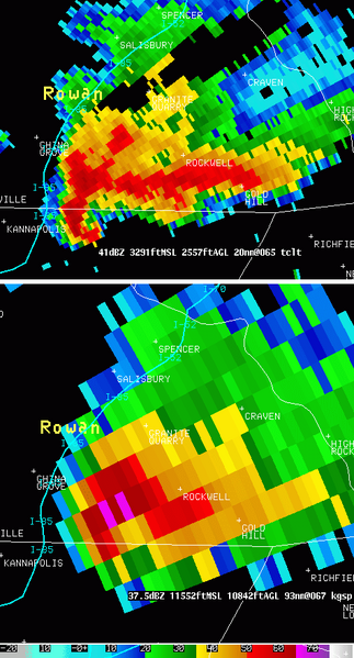
Radar reflectivity at 0.5 degree scan from the KGSP WSR-88D (NEXRAD) at 1844 UTC (right) and Radar reflectivity at 1.0 degree scan from the TCLT TDWR, colocated, at 1842 UTC on left. One can notice easily the improved resolution on the TDWR but the attenuation region caused by the heavy precipitations when compared to NEXRAD data
|
| Date | |
| Source | http://www.erh.noaa.gov/gsp/tdwr/info/specs.html |
| Author | National Weather Service of the United States |
|
Permission
( Reusing this file ) |
Public domain. |
Licensing
|
|
This image is in the
public domain
because it contains materials that originally came from the U.S.
National Oceanic and Atmospheric Administration
, taken or made as part of an employee's official duties.
|
|