Sudbury_railway_station,_Suffolk.jpg

Size of this preview:
800 × 600 pixels
.
Other resolutions:
320 × 240 pixels
|
640 × 480 pixels
|
1,024 × 768 pixels
.
Summary
| Description |
English:
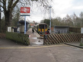
Opened in 1991 by British Rail at the end of the line from Marks Tey, this replaced Sudbury's 2nd (1865-1991) station over to the right of this image, which had been on a through route from Marks Tey to Cambridge. View east past the buffers. Sudbury's 1st (1849-1865) station had also been a terminus, situated out of view behind the camera position and to the left.
|
| Date | |
| Source | From geograph.org.uk |
| Author | Nigel Thompson |
|
Attribution
( required by the license ) |
Nigel Thompson / Sudbury railway station, Suffolk / |
| Camera location |
|
View this and other nearby images on: OpenStreetMap |
|
|---|
_heading:112.00&language=en)
| Object location |
|
View this and other nearby images on: OpenStreetMap |
|
|---|
_heading:112.00&language=en)
Licensing

|
This image was taken from the
Geograph project
collection. See
this photograph's page
on the Geograph website for the photographer's contact details. The copyright on this image is owned by
Nigel Thompson
and is licensed for reuse under the
Creative Commons
Attribution-ShareAlike 2.0 license.
|
This file is licensed under the
Creative Commons
Attribution-Share Alike 2.0 Generic
license.
Attribution:
Nigel Thompson
-
You are free:
- to share – to copy, distribute and transmit the work
- to remix – to adapt the work
-
Under the following conditions:
- attribution – You must give appropriate credit, provide a link to the license, and indicate if changes were made. You may do so in any reasonable manner, but not in any way that suggests the licensor endorses you or your use.
- share alike – If you remix, transform, or build upon the material, you must distribute your contributions under the same or compatible license as the original.