Spread_of_Christianity_to_AD_600_(1).png

Size of this preview:
800 × 592 pixels
.
Other resolutions:
320 × 237 pixels
|
640 × 474 pixels
|
1,024 × 758 pixels
|
1,280 × 948 pixels
|
2,187 × 1,619 pixels
.
Summary
| Description |
English:
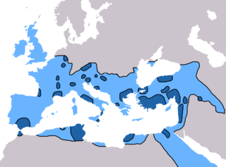
Map of the spread of Christianity in Europe, Southwest Asia and North Africa to the year AD 600.
"redominantly Christian by AD 325" zone coloured in dark blue, "Predominantly Christian by AD 600" coloured in light blue.
Predominantly Christian by AD 325
Predominantly Christian by AD 600
Magyar:
A kereszténység elterjedése:
Kr. u. 325-ig
325 és 600 között
Information obtained from Patrick O'Brien , ed. (2003) Atlas of World History , Category:New York : Oxford University Press, pp. 44−5 0-19-521921-X Map created and uploaded in the English Wikipedia by Geuiwogbil . Base map: " File:BlankMap-Europe-v3.png " |
| Date | 27 May 2009 (original upload date) |
| Source | Transferred from en.wikipedia to Commons by QuartierLatin1968 using CommonsHelper . |
| Author | Geuiwogbil at English Wikipedia |

|
This
religion map
image could be re-created
using
vector graphics
as an
SVG
file
. This has several advantages; see
Commons:Media for cleanup
for more information. If an SVG form of this image is available, please upload it and afterwards replace this template with
{{

vector version available

|

new image name

}}
.
It is recommended to name the SVG file “Spread of Christianity to AD 600 - Atlas of World History.svg”—then the template Vector version available (or Vva ) does not need the new image name parameter. |
Licensing
Geuiwogbil
at the
English-language Wikipedia
, the copyright holder of this work, hereby publishes it under the following license:
|
|
This file is licensed under the Creative Commons Attribution-Share Alike 3.0 Unported license. Subject to disclaimers . | |
| Attribution: Geuiwogbil at the English-language Wikipedia | ||
|
||
| This licensing tag was added to this file as part of the GFDL licensing update . |

|
Permission is granted to copy, distribute and/or modify this document under the terms of the GNU Free Documentation License , Version 1.2 or any later version published by the Free Software Foundation ; with no Invariant Sections, no Front-Cover Texts, and no Back-Cover Texts. A copy of the license is included in the section entitled GNU Free Documentation License . Subject to disclaimers . |
Original upload log
The original description page was
here
. All following user names refer to en.wikipedia.
- 2009-05-27 19:20 Carlaude 2187×1619× (232587 bytes) Cutting out unused areas of the map
- 2006-09-09 02:34 Geuiwogbil 2285×2181× (248280 bytes) Blue provides us with a better constrast.
- 2006-09-04 05:10 Geuiwogbil 2285×2181× (254524 bytes)
- 2006-09-04 05:08 Geuiwogbil 2285×2181× (116034 bytes) Map of the spread of Christianity in Europe, Southwest Asia and North Africa to the year 600 AD. Base map "BlankMap-Europe-v.3." Spread of Christianity to AD 325 coloured in orange, to 600 coloured in yellow. Information obtained from {{cite book |editor=