Scraesdon_Fort_-_Caponier_-_geograph.org.uk_-_345243.jpg
No higher resolution available.
Summary
| Description |
English:
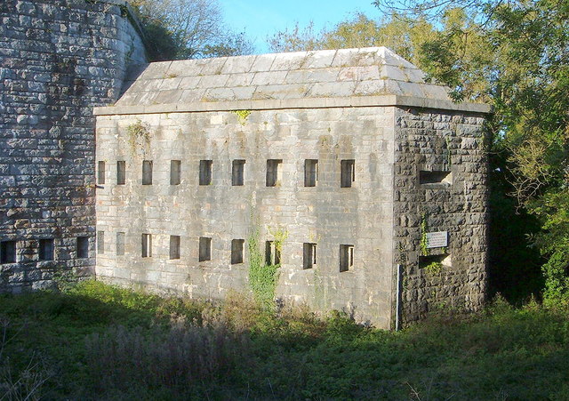
Scraesdon Fort - Caponier Picture of a Fortified Caponier. The fire coming from here would sweep across the entrance to the fort, inflicting devastating damage on any attempt to storm the fortificaton.
To avoid fire from one caponier bearing on the next, caponiers are usually set at alternate corners of the fort, so that they fire towards a blank wall at the opposite end of the ditch, giving full coverage of the ditch without subjecting the next caponier to fire. The length of the straight sections of the ditch is chosen so that it can be covered by fire from a single caponier. Caponiers are often wedge shaped so that they can fire down both angles of the ditch. Caponiers are a common feature of 19th century fortification, and are found on almost all the Victorian forts of Malta and the Palmerston Forts in UK - like this one. |
| Date | |
| Source | From geograph.org.uk |
| Author | Bill Booth |
| Camera location |
|
View this and other nearby images on: OpenStreetMap |
|
|---|
_heading:315.00&language=en)
| Object location |
|
View this and other nearby images on: OpenStreetMap |
|
|---|
_heading:315.00&language=en)
Licensing

|
This image was taken from the
Geograph project
collection. See
this photograph's page
on the Geograph website for the photographer's contact details. The copyright on this image is owned by
Bill Booth
and is licensed for reuse under the
Creative Commons
Attribution-ShareAlike 2.0 license.
|
This file is licensed under the
Creative Commons
Attribution-Share Alike 2.0 Generic
license.
Attribution:
Bill Booth
-
You are free:
- to share – to copy, distribute and transmit the work
- to remix – to adapt the work
-
Under the following conditions:
- attribution – You must give appropriate credit, provide a link to the license, and indicate if changes were made. You may do so in any reasonable manner, but not in any way that suggests the licensor endorses you or your use.
- share alike – If you remix, transform, or build upon the material, you must distribute your contributions under the same or compatible license as the original.