Schleienloecher2-1-_C.jpg

Size of this preview:
800 × 435 pixels
.
Other resolutions:
320 × 174 pixels
|
640 × 348 pixels
|
1,024 × 557 pixels
|
1,280 × 696 pixels
|
3,008 × 1,635 pixels
.
|

|
|
This image was selected as
picture of the day
on Wikimedia Commons for
28 September 2007
. It was captioned as follows:
English:
The nature reserve
Schleienlöcher
in
Hard
,
Austria
.
Other languages:
Čeština
:
Přírodní rezervace
Schleienlöcher
,
Hard
,
Rakousko
.
English
:
The nature reserve
Schleienlöcher
in
Hard
,
Austria
.
Euskara
:
Austriako
Schleienlöcher
erreserba naturala
Magyar
:
Schleienlöcher természetvédelnmi terület az
ausztriai
Hard-ban
Nederlands
:
Het natuurreservaat
Schleienlöcher
in
Hard
,
Oostenrijk
.
日本語
:
オーストリア、
ハード
の
Schleienlöcher
自然保護区
|
| Description |
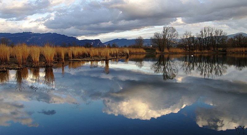
Deutsch:
Schilfrohr
im Naturschutzgebiet
Schleienlöcher
in
Hard
(
Vorarlberg
)
mit Blick zum Pfänder, zum
Gebhardsberg
und in den vorderen
Bregenzerwald
. Veröffentlicht: Georg Kessler in "Freizeit im Ländle, Die schönsten Ausflugziele in Vorarlberg
ISBN
978-3-7022-3068-5
2010
English:
The
Schleienlöcher
nature reserve in Hard (
Austria
) with view towards the
Pfänder
the
Gebhardsberg
and the
Bregenzerwald
.
Français :
Réserve naturelle du
Schleienlöcher
dans la commune de Hard, en
Autriche
(Land de Vorarlberg). Les sommets visibles en arrière plan sont le Pfänder (dans les
Alpes d'Allgäu
, le Gebhardsberg et le
Bregenzerwald
.
Русский:
Заповедник
Шлейенлюхер
в
Гарде
(Австрия) с видом на
Пфюндер
,
Гебхардсберг
и
Брегензервальд
.
|
| Date | |
| Source | Own work |
| Author | Böhringer Friedrich – (slightly edited by Vassil ) |
|
Permission
( Reusing this file ) |
This file is licensed under the
Creative Commons
Attribution-Share Alike 2.5 Generic
license.
|
| Other versions |
|


|
This Photo was taken by
Böhringer Friedrich
.
|
Feel free to use my photos, but please mention me as the author and if you want send me a
message
. or (
[email protected]
)
|
| Camera location |
|
View this and other nearby images on: OpenStreetMap |
|
|---|
| Annotations | This image is annotated: View the annotations at Commons |