Scandinavian_States.svg

Size of this PNG preview of this SVG file:
636 × 599 pixels
.
Other resolutions:
255 × 240 pixels
|
509 × 480 pixels
|
815 × 768 pixels
|
1,087 × 1,024 pixels
|
2,174 × 2,048 pixels
|
1,090 × 1,027 pixels
.
| Description |
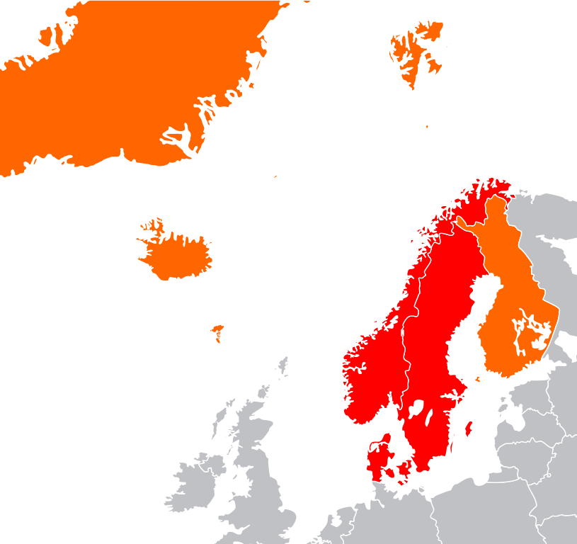
English:
Map showing two of the common definitions of "Scandinavia"; a cultural, historical and ethno-linguistic region in northern Europe:
the most common usage: the three monarchies; Denmark, Norway and Sweden
an extended usage: including Finland, Iceland and the Faroe Islands
Русский:
Карта показывает
страны Северной Европы
:
Страны Скандинавии
: Дания, Норвегия и Швеция
Другие страны: Финляндия, Исландия, Гренландия и Фарерские острова
|
| Date | (UTC) |
| Source | |
| Author |
|
|
|
This is a
retouched picture
, which means that it has been digitally altered from its original version. The original can be viewed here:
Location European nation states.svg
:
|
I, the copyright holder of this work, hereby publish it under the following licenses:
|
|
This file is licensed under the Creative Commons Attribution-Share Alike 3.0 Unported license. | |
|
||
| This licensing tag was added to this file as part of the GFDL licensing update . |

|
Permission is granted to copy, distribute and/or modify this document under the terms of the GNU Free Documentation License , Version 1.2 or any later version published by the Free Software Foundation ; with no Invariant Sections, no Front-Cover Texts, and no Back-Cover Texts. A copy of the license is included in the section entitled GNU Free Documentation License . |
You may select the license of your choice.
Original upload log
This image is a derivative work of the following images:
-
File:Location_European_nation_states.svg
licensed with Cc-by-sa-3.0-migrated, GFDL
- 2010-10-09T15:55:16Z LX 2045x1720 (748293 Bytes) Reverted sockpuppet edits to version as of 15:03, 11 November 2009
- 2010-10-02T06:27:34Z Lartyo 2045x1720 (730891 Bytes) Reverted to version as of 20:37, 18 October 2009
- 2009-11-11T15:03:57Z NuclearVacuum 2045x1720 (748293 Bytes) minor
- 2009-11-11T14:59:54Z NuclearVacuum 2045x1720 (733426 Bytes) territorial fixes
- 2009-10-18T20:37:51Z NuclearVacuum 2045x1720 (730891 Bytes) several countries did not include all its territories
- 2008-12-04T00:44:42Z Ssolbergj 2045x1720 (726069 Bytes) Kosovo
- 2008-06-20T13:09:36Z Ssolbergj 2045x1720 (724181 Bytes) Reverted to version as of 00:57, 12 June 2008
- 2008-06-19T17:59:14Z Ssolbergj 2045x1720 (719110 Bytes) {{Information |Description= |Source= |Date= |Author= |Permission= |other_versions= }}
- 2008-06-12T00:57:39Z Ssolbergj 2045x1720 (724181 Bytes) {{Information |Description={{en|1=SVG map of Europe. Borders of nation states.}} {{no|1=SVG-kart over Europa. Nasjonstatlige grenser.}} |Source=[[:Image:Location Spain EU Europe 1.svg]] |Author=[[:en:User:Ssolbergj|Ssolbergj]
Uploaded with derivativeFX