Satellite_view_of_fog_over_the_Golden_Gate.jpg

Size of this preview:
400 × 600 pixels
.
Other resolutions:
160 × 240 pixels
|
320 × 480 pixels
|
512 × 768 pixels
|
683 × 1,024 pixels
|
1,365 × 2,048 pixels
|
2,721 × 4,081 pixels
.
Summary
| Description |
English:
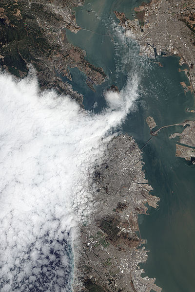
The Advanced Land Imager (ALI) on NASA’s Earth Observing-1 (EO-1) satellite acquired this view of fog encroaching on the city on August 16, 2012. The fog is part of the marine layer, a mass of cool, dense air from the sea that was sandwiched beneath a layer of warmer air as part of a temperature inversion. Fog is often present in the lower part of the marine layer, whereas wispy stratus clouds form in the upper part.
|
| Date | |
| Source | http://earthobservatory.nasa.gov/IOTD/view.php?id=79119 |
| Author | NASA Earth Observatory image by Jesse Allen and Robert Simmon, using EO-1 ALI data from the NASA EO-1 team. |
| Camera location |
|
View this and other nearby images on: OpenStreetMap |
|
|---|
Licensing
|
|
This file is in the public domain in the United States because it was solely created by NASA . NASA copyright policy states that "NASA material is not protected by copyright unless noted ". (See Template:PD-USGov , NASA copyright policy page or JPL Image Use Policy .) |
|

|
Warnings:
|