Saint_Martin_map.svg

Size of this PNG preview of this SVG file:
800 × 558 pixels
.
Other resolutions:
320 × 223 pixels
|
640 × 447 pixels
|
1,024 × 715 pixels
|
1,280 × 894 pixels
|
2,560 × 1,787 pixels
|
1,060 × 740 pixels
.
Summary
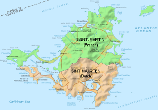
| Description | Map of of the island of St Martin, with political division | ||
| Date | |||
| Source | Saint-Martin Island map-en.svg | ||
| Author | Hogweard | ||
|
Permission
( Reusing this file ) |
I, the copyright holder of this work, hereby publish it under the following licenses:
This file is licensed under the
Creative Commons
Attribution-Share Alike 3.0 Unported
license.
You may select the license of your choice.
|
