Sachsenring.svg

Size of this PNG preview of this SVG file:
800 × 405 pixels
.
Other resolutions:
320 × 162 pixels
|
640 × 324 pixels
|
1,024 × 518 pixels
|
1,280 × 648 pixels
|
2,560 × 1,296 pixels
|
1,462 × 740 pixels
.
Summary
| Description |
English:
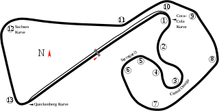
Track map of
Sachsenring
. No pit area for the "Omega Circuit" (the right half of the image) was found.
|
| SVG development | |
| Date | 8-6-2008 |
| Source | openstreetmap.org |
| Creator |
OpenStreetMap contributors
|
|
Permission
( Reusing this file ) |
OpenStreetMap data and maps are licensed under the
Creative Commons
Attribution-ShareAlike 2.0 license (CC-BY-SA 2.0).
This file is licensed under the
Creative Commons
Attribution-Share Alike 2.0 Generic
license.
|
| Georeferencing | If inappropriate please set warp_status = skip to hide. |
| Other versions |
|


| Camera location |
|
View this and other nearby images on: OpenStreetMap |
|
|---|