SBIRS-GEO.jpg
| Description SBIRS-GEO.jpg |
English:
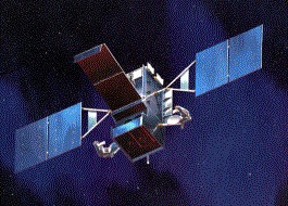
SPACE BASED INFRARED SYSTEMS (SBIRS)
SBIRS High features a mix of four geosynchronous earth orbit (GEO) satellites, two highly elliptical earth orbit (HEO) payloads, and associated ground hardware and software. SBIRS High will have both improved sensor flexibility and sensitivity. Sensors will cover short-wave infrared like its predecessor, expanded mid-wave infrared and see-to-the-ground bands allowing it to perform a broader set of missions as compared to DSP. Currently in the engineering, manufacturing, and development phase, the first SBIRS High HEO payload is scheduled for delivery in 2003 and the first GEO satellite is expected to launch in 2006
|
| Source | http://www.losangeles.af.mil/library/factsheets/factsheet_media.asp?fsID=5330 |
| Author | US Air Force |
| Public domain Public domain false false |
|
|
This image or file is a work of a
U.S. Air Force
Airman or employee, taken or made as part of that person's official duties. As a
work
of the
U.S. federal government
, the image or file is in the
public domain
in the United States.
العربية ∙ беларуская (тарашкевіца) ∙ català ∙ čeština ∙ Deutsch ∙ English ∙ español ∙ eesti ∙ فارسی ∙ suomi ∙ français ∙ italiano ∙ 日本語 ∙ 한국어 ∙ македонски ∙ മലയാളം ∙ မြန်မာဘာသာ ∙ norsk bokmål ∙ Plattdüütsch ∙ Nederlands ∙ polski ∙ português ∙ português do Brasil ∙ русский ∙ sicilianu ∙ slovenčina ∙ slovenščina ∙ српски / srpski ∙ svenska ∙ Türkçe ∙ українська ∙ Tiếng Việt ∙ 中文(简体) ∙ 中文(繁體) ∙ +/− |

|

