Round_Tower_-_Clondalkin_-_geograph.org.uk_-_108911.jpg
Size of this preview:
449 × 600 pixels
.
Other resolutions:
179 × 240 pixels
|
479 × 640 pixels
.
Summary
| Description |
English:
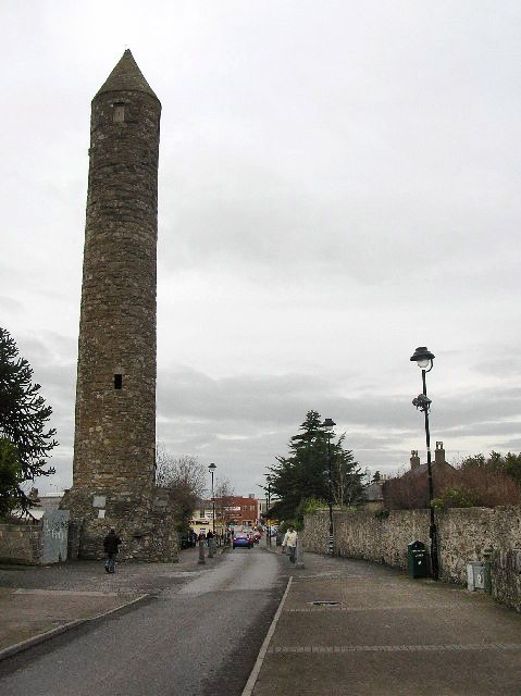
Round Tower - Clondalkin. Well preserved 8th century round tower that acts as a focal point for the area. Acknowledged as one of the oldest and best preserved in the country, it is 84 feet high and has its original conical cap. The foundation of the first monastery is attributed to St. Cronan, otherwise called Mo-Chua, who lived possibly in the 6th century. The monastery is first mentioned in 776. It was plundered by the Vikings in 832. [info from
http://www.irish-architecture.com
]
|
| Date | |
| Source | From geograph.org.uk |
| Author | Paul Johnston-Knight |
|
Attribution
( required by the license ) |
Paul Johnston-Knight / Round Tower - Clondalkin / |
| Object location |
|
View this and other nearby images on: OpenStreetMap |
|
|---|
_heading:0.00&language=en)
Licensing

|
This image was taken from the
Geograph project
collection. See
this photograph's page
on the Geograph website for the photographer's contact details. The copyright on this image is owned by
Paul Johnston-Knight
and is licensed for reuse under the
Creative Commons
Attribution-ShareAlike 2.0 license.
|
This file is licensed under the
Creative Commons
Attribution-Share Alike 2.0 Generic
license.
Attribution:
Paul Johnston-Knight
-
You are free:
- to share – to copy, distribute and transmit the work
- to remix – to adapt the work
-
Under the following conditions:
- attribution – You must give appropriate credit, provide a link to the license, and indicate if changes were made. You may do so in any reasonable manner, but not in any way that suggests the licensor endorses you or your use.
- share alike – If you remix, transform, or build upon the material, you must distribute your contributions under the same or compatible license as the original.