Port_of_Rotterdam_Landsat_8_Photo_8_May_2016.jpg

Size of this preview:
800 × 252 pixels
.
Other resolutions:
320 × 101 pixels
|
640 × 201 pixels
|
1,024 × 322 pixels
|
1,280 × 403 pixels
|
5,016 × 1,578 pixels
.
Summary
| Description |
English:
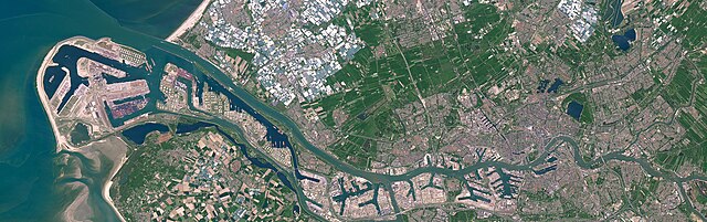
Satellite photo of the Port of Rotterdam in South Holland, the Netherlands. This image was captured on May 8, 2016 by the Operational Land Imager (OLI) on the Landsat 8 satellite.
Nederlands:
Satellietfoto van de haven van Rotterdam in Zuid-Holland, Nederland. Deze foto is op 8 mei 2016 gemaakt door de Operational Land Imager (OLI) op de Landsat 8 satelliet.
|
| Date | |
| Source | NASA Earth Observatory - https://earthobservatory.nasa.gov/images/91317/holland-first-stop-for-the-pilgrims |
| Author | NASA Earth Observatory images by Joshua Stevens, using Landsat data from the U.S. Geological Survey. Story by Adam Voiland. |
Licensing
|
|
This file is in the public domain in the United States because it was solely created by NASA . NASA copyright policy states that "NASA material is not protected by copyright unless noted ". (See Template:PD-USGov , NASA copyright policy page or JPL Image Use Policy .) |
|

|
Warnings:
|