PittsburghMinedOut1973.png

Size of this preview:
315 × 600 pixels
.
Other resolutions:
126 × 240 pixels
|
252 × 480 pixels
|
805 × 1,533 pixels
.
Summary
| Description |
English:
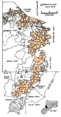
Original caption: "Figure 6, - Areas of the Pittsburgh coalbed that have been mined out." The legend originally incorporated into the figure named the mines: "1 Montour No. 4; 2 Mathies; 3 Maple Creek; 4 Westland; 5 Somerset No. 60; 6 Vesta No. 4; 7 Vesta No. 5; 8 Marianna No. 58; 9 Gateway; 10 Mather colleries; 11 Humphrey No. 7; 12 Shannopin; 13 Blacksville No. 2; 14 Blacksville No. 1; 15 Pursglove; 16 Osage No. 3; 17 Federal No. 2; 18 Arkwright; 19 Loveridge; 20 Federal No. 1; 21 Consol No. 93; 22 Consol No. 9; 23 Joanne; 24 Bethlehem No. 41; 25 Bethlehem No. 44; 26 Consol No. 20; 27 Robena; 28 Nemacolin; 29 Crucible; 30 Bethlehem No 51." The mined out areas have been colorized and the key relocated by the uploader, who claims no rights to these modifications.
|
| Date | |
| Source | Selected Geologic Factors Affecting Mining of the Pittsburgh Coalbed , United States Bureau of Mines, RI 8093 |
| Author | C. M. McCulloch, W. P. Diamond, B. M. Bench, Maurice Deul |
Licensing
|
|
This image is a work of the
Centers for Disease Control and Prevention
, part of the
United States Department of Health and Human Services
, taken or made as part of an employee's official duties. As a work of the
U.S. federal government
, the image is in the
public domain
.
|
|