Piliers_de_tutelle_(Bordeaux_1669)_(cropped).JPG

Size of this preview:
739 × 599 pixels
.
Other resolutions:
296 × 240 pixels
|
592 × 480 pixels
|
947 × 768 pixels
|
1,262 × 1,024 pixels
|
1,605 × 1,302 pixels
.
Summary
| Description |
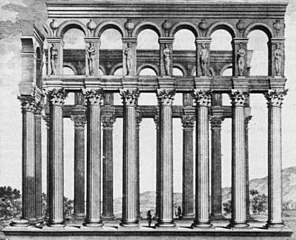
Français :
Edifice gallo-romain du III
e
siècle
piliers de tutelle
à Bordeaux détruit en 1675. Dessin et plan de Claude Perrault (1613-1688) à l'occasion d'un voyage à Bordeaux en 1669, gravé par Pierre Lepautre vers 1684.
English:
Gallo-roman building of the IIIrd century named
piliers de tutelle
in Bordeaux (France). Destroyed in 1675. Drawing and map by Claude Perrault (1613-1688), engraved by Pierre Lepautre.
|
||||||||||||||||||||||||||||||||||||||||||||||||
| Date | |||||||||||||||||||||||||||||||||||||||||||||||||
| Source | Claude Perrault, Les dix livres d'architecture de Vitruve, 2ème édition 1684. | ||||||||||||||||||||||||||||||||||||||||||||||||
| Author |
Designer :
|
||||||||||||||||||||||||||||||||||||||||||||||||
| Other versions | |||||||||||||||||||||||||||||||||||||||||||||||||

.JPG)
| Object location |
|
View this and other nearby images on: OpenStreetMap |
|
|---|
_(cropped).JPG¶ms=044.842854_N_-000.574443_E_globe:Earth_class:object_type:object_region:FR_&language=en)
Licensing
|
This is a faithful photographic reproduction of a two-dimensional,
public domain
work of art. The work of art itself is in the public domain for the following reason:
The official position taken by the Wikimedia Foundation is that "
faithful reproductions of two-dimensional public domain works of art are public domain
".
This photographic reproduction is therefore also considered to be in the public domain in the United States. In other jurisdictions, re-use of this content may be restricted; see Reuse of PD-Art photographs for details. |
||||