Pedro_De_Valdivia_Siedlungen_in_Chile_1540_bis_1553.jpg
Size of this preview:
187 × 600 pixels
.
Other resolution:
300 × 962 pixels
.

|
This
historical map
image could be re-created
using
vector graphics
as an
SVG
file
. This has several advantages; see
Commons:Media for cleanup
for more information. If an SVG form of this image is available, please upload it and afterwards replace this template with
{{

vector version available

|

new image name

}}
.
It is recommended to name the SVG file “Pedro De Valdivia Siedlungen in Chile 1540 bis 1553.svg”—then the template Vector version available (or Vva ) does not need the new image name parameter. |


| Description |
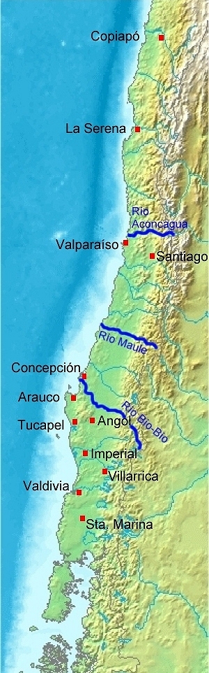
Deutsch:
Karte von
Chile
. Pedro de Valdivia. Koloniale Siedlungen in Chile, 1540 - 1553
English:
Map of
Chile
. Pedro de Valdivia. Locations of colonization in Chile, 1540 - 1553
Español:
Mapa de
Chile
. Pedro de Valdivia. Fundaciones en Chile, 1540 - 1553
|
| Date | (UTC) |
| Source | |
| Author |
|
| Other versions | العربيَّة |
|
|
This is a
retouched picture
, which means that it has been digitally altered from its original version. Modifications:
Orte eingezeichnet/locations added
. The original can be viewed here:
Map of Chile Demis.png
:
|
|
|
This image is in the
public domain
because it came from the site
https://www.demis.nl/products/web-map-server/examples/
and was released by the
copyright
holder. Permission is granted to copy, distribute and/or modify this map since it is based on free of copyright images from:
www.demis.nl
. See also
approval email on de.wp
and
its clarification
.
|
|
|
This work has been released into the
public domain
by its
copyright
holder,
www.demis.nl
. This applies worldwide.
In some countries this may not be legally possible; if so: www.demis.nl grants anyone the right to use this work for any purpose , without any conditions, unless such conditions are required by law.
|
Original upload log
This image is a derivative work of the following images:
-
Image:Map_of_Chile_Demis.png
licensed with PD-Demis
- 2006-12-20T19:50:53Z Mats Halldin 343x1458 (269160 Bytes) Map of [[Chile]] Bounding box West -78°, South -57°, East -66°, North -16°. Center at {{coor d|36.50000|S|72.00000|W|scale:24600000}}. {{demis-pd}} [[category:maps of Chile]]
Uploaded with derivativeFX