Okazaki_in_Aichi_Prefecture_Ja.svg

Size of this PNG preview of this SVG file:
539 × 484 pixels
.
Other resolutions:
267 × 240 pixels
|
535 × 480 pixels
|
855 × 768 pixels
|
1,140 × 1,024 pixels
|
2,281 × 2,048 pixels
.
Summary
| Description |
English:
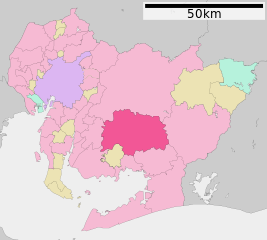
Okazaki in Aichi Prefecture
|
||
| Date | 更新:2010年3月22日 | ||
| Source |
|
||
| Author | Lincun | ||
|
Permission
( Reusing this file ) |
|
Licensing

|
Permission is granted to copy, distribute and/or modify this document under the terms of the GNU Free Documentation License , Version 1.2 or any later version published by the Free Software Foundation ; with no Invariant Sections, no Front-Cover Texts, and no Back-Cover Texts. A copy of the license is included in the section entitled GNU Free Documentation License . |
This file is licensed under the
Creative Commons
Attribution-Share Alike 3.0 Unported
license.
-
You are free:
- to share – to copy, distribute and transmit the work
- to remix – to adapt the work
-
Under the following conditions:
- attribution – You must give appropriate credit, provide a link to the license, and indicate if changes were made. You may do so in any reasonable manner, but not in any way that suggests the licensor endorses you or your use.
- share alike – If you remix, transform, or build upon the material, you must distribute your contributions under the same or compatible license as the original.
Original upload log
|
|
This file was moved from
Japanese Wikipedia
.
See below for original file information. |
|||||||||||||||||||||||||||||||||||||||||||||||||||||||||||||||||||||||
|
||||||||||||||||||||||||||||||||||||||||||||||||||||||||||||||||||||||||
|
|
||||||||||||||||||||||||||||||||||||||||||||||||||||||||||||||||||||||||