Nürburgring_-_Grand-Prix_Stecke.svg

Size of this PNG preview of this SVG file:
800 × 473 pixels
.
Other resolutions:
320 × 189 pixels
|
640 × 378 pixels
|
1,024 × 605 pixels
|
1,280 × 757 pixels
|
2,560 × 1,514 pixels
|
920 × 544 pixels
.
Summary
| Description | |
| Date | |
| Source | Own work |
| Author | Will Pittenger |
| Other versions |
|

| Camera location |
|
View this and other nearby images on: OpenStreetMap |
|
|---|
Editing note
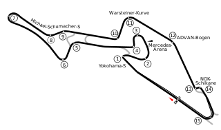
If you need to edit this image, please preserve the hidden layer. It is a backup of the track sections. The visible layer has all track sections stroked to paths so they can have a white border. This allows me to display the image on a dark background if needed. If I get information on the Formula 1 sectors, I will use that backup layer to generate those. I might also need the backup to make any corrections. The exact position of the Mercedes Arena couldn't be located as Google Earth doesn't show it yet.
Licensing
|
|
I, the copyright holder of this work, release this work into the
public domain
. This applies worldwide.
In some countries this may not be legally possible; if so: I grant anyone the right to use this work for any purpose , without any conditions, unless such conditions are required by law. |