Nunavik_map.svg

Size of this PNG preview of this SVG file:
516 × 599 pixels
.
Other resolutions:
207 × 240 pixels
|
413 × 480 pixels
|
661 × 768 pixels
|
882 × 1,024 pixels
|
1,763 × 2,048 pixels
|
1,184 × 1,375 pixels
.
Summary
| Description |
English:
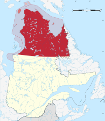
Nunavik as definied by the Makivik Corporation, highlighted on the map of Quebec, Canada. Territory within the Province of Quebec is coloured dark red, offshore islands that are part of Nunavut are in lighter red. Islands claimed as joint Nunavut-Nunavik territory are hatched.
|
| Date | |
| Source | Own work , base map from File:Canada Quebec location map-conic proj2.svg , borders from [1] and [2] |
| Author | Fenn-O-maniC |
Licensing
I, the copyright holder of this work, hereby publish it under the following license:
This file is licensed under the
Creative Commons
Attribution-Share Alike 4.0 International
license.
-
You are free:
- to share – to copy, distribute and transmit the work
- to remix – to adapt the work
-
Under the following conditions:
- attribution – You must give appropriate credit, provide a link to the license, and indicate if changes were made. You may do so in any reasonable manner, but not in any way that suggests the licensor endorses you or your use.
- share alike – If you remix, transform, or build upon the material, you must distribute your contributions under the same or compatible license as the original.