Northern_Syria_offensive_(2015).png
Size of this preview:
800 × 561 pixels
.
Other resolutions:
320 × 224 pixels
|
640 × 449 pixels
|
1,024 × 718 pixels
|
1,280 × 898 pixels
|
1,544 × 1,083 pixels
.
Summary
| Description |
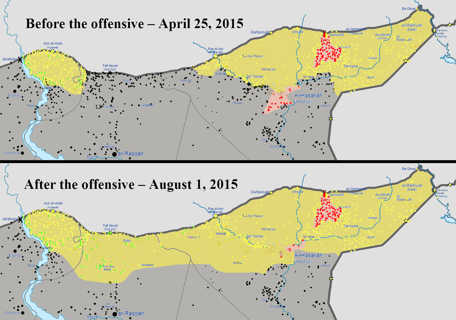
English:
Map of the territorial gains made by the Kurdish
YPG
and their allied during the Northern Syria offensive (2015), dubbed
Operation Rûbar Qamishlo
by the Kurds. The Northern Syria offensive lasted from May to July 2015, which was comprised of the
Al-Hasakah offensive (May 2015)
, and the
Tell Abyad offensive (2015)
. The offensive was the largest offensive carried out by the YPG against the
Islamic State of Iraq and the Levant
, which saw the Kurdish-led forces capture 6,835 square miles (11,000 square kilometers) of land, and over 900 towns and villages from ISIL. By early August 2015, ISIL had lost over 10,000 militants in Northern Syria, in clashes against YPG and the FSA during their offensive operations. The outcome of the offensive was deemed to be one of the biggest defeats dealt to ISIL, with the recent Kurdish advances stripping ISIL of multiple strongholds it once controlled, as well as crucial supply routes to Turkey.
|
| Date | |
| Source | Own work |
| Author | BlueHypercane761 |
Licensing
I, the copyright holder of this work, hereby publish it under the following license:
This file is licensed under the
Creative Commons
Attribution-Share Alike 4.0 International
license.
-
You are free:
- to share – to copy, distribute and transmit the work
- to remix – to adapt the work
-
Under the following conditions:
- attribution – You must give appropriate credit, provide a link to the license, and indicate if changes were made. You may do so in any reasonable manner, but not in any way that suggests the licensor endorses you or your use.
- share alike – If you remix, transform, or build upon the material, you must distribute your contributions under the same or compatible license as the original.