New_2000_black_percent.gif

Size of this preview:
776 × 600 pixels
.
Other resolutions:
311 × 240 pixels
|
621 × 480 pixels
|
994 × 768 pixels
|
1,280 × 989 pixels
|
2,604 × 2,012 pixels
.
Summary

|
This
ethnographic map
image could be re-created
using
vector graphics
as an
SVG
file
. This has several advantages; see
Commons:Media for cleanup
for more information. If an SVG form of this image is available, please upload it and afterwards replace this template with
{{

vector version available

|

new image name

}}
.
It is recommended to name the SVG file “New 2000 black percent.svg”—then the template Vector version available (or Vva ) does not need the new image name parameter. |
| Description |
English:
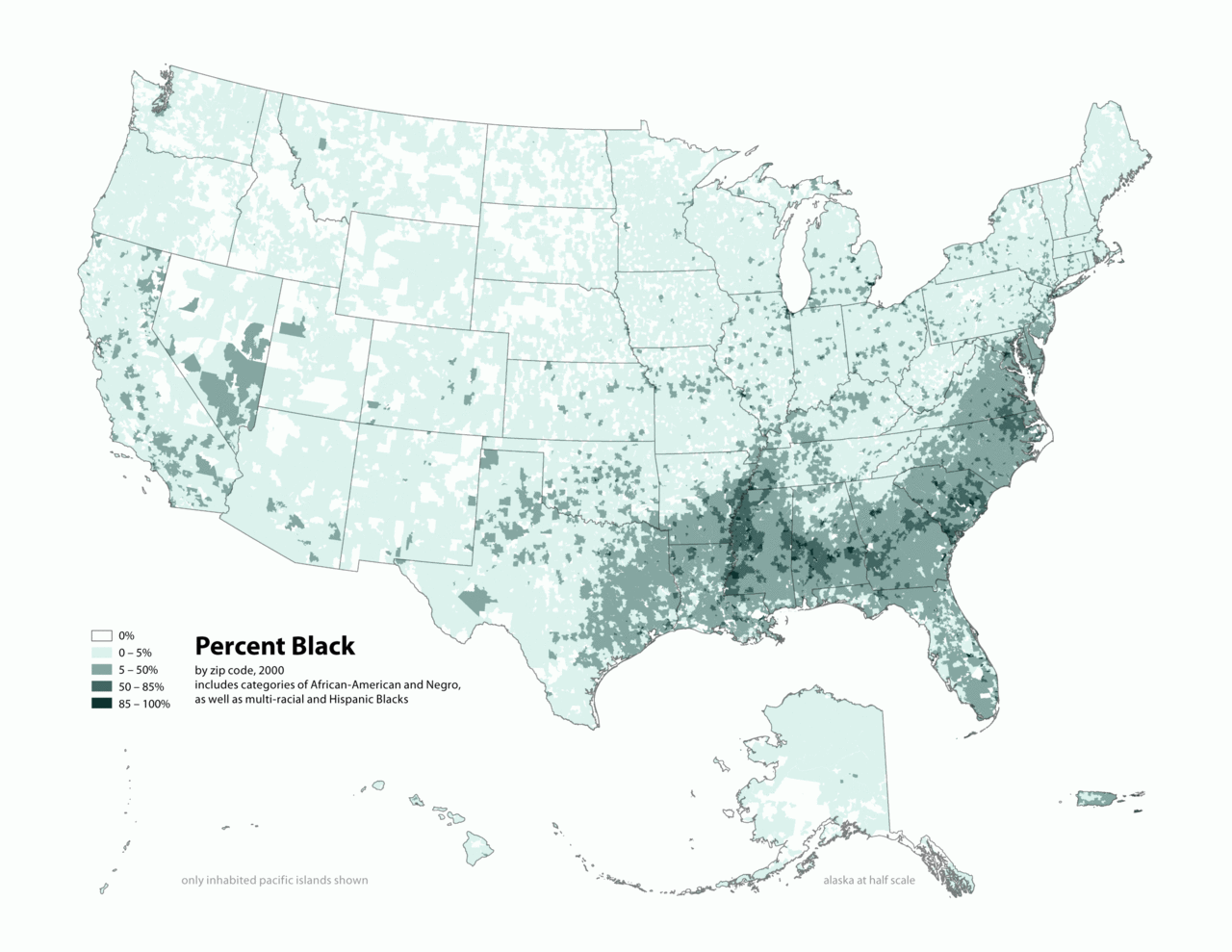
Map of contiguous US, showing percentage of population self-reported as "Black," by census tract, 2000. Data source: US Census.
|
| Date | 3 April 2006 (original upload date) |
| Source | Transferred from en.wikipedia to Commons by O'Dea . |
| Author | The original uploader was Citynoise at English Wikipedia . |
Licensing
This file is licensed under the
Creative Commons
Attribution-Share Alike 2.5 Generic
license.
-
You are free:
- to share – to copy, distribute and transmit the work
- to remix – to adapt the work
-
Under the following conditions:
- attribution – You must give appropriate credit, provide a link to the license, and indicate if changes were made. You may do so in any reasonable manner, but not in any way that suggests the licensor endorses you or your use.
- share alike – If you remix, transform, or build upon the material, you must distribute your contributions under the same or compatible license as the original.
Original upload log
The original description page was
here
. All following user names refer to en.wikipedia.
- 2010-05-01 19:15 Citynoise 2604×2012× (664072 bytes) Added Alaska, Hawaii, and Territories. Also changed from tracts to zip codes.
- 2006-04-03 02:04 Citynoise 1012×691× (78990 bytes) Map of contiguous US, showing percentage of population self-reported as "Black," by census tract, 2000. Data source: US Census. I am the designer and creator of this map and license it under the Creative Commons Attribution ShareAlike 2.5 License. s
Category:Census maps of the United States Category:Maps illustrating African American history Category:African American history