Neutral_Buoyancy_Space_Simulator.jpg
No higher resolution available.
|
|
This is an image of a place or building that is listed on the
National Register of Historic Places
in the
United States of America
. Its reference number is
85002807
.
|
| Camera location |
|
View this and other nearby images on: OpenStreetMap |
|
|---|
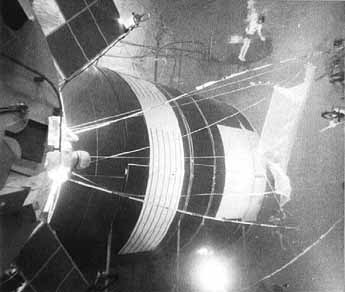
| Description | Rigging of the protective shields for Skylab was rehearsed many times in the neutral buoyancy simulator. Here, a shield made of netting (for simulation only) is being rigged underwater to determine the problems that would be encountered in space. | |||||
| Date | Uploaded on 2 August 2007 | |||||
| Source | ||||||
| Author | NASA | |||||
|
Permission
( Reusing this file ) |
|
