NY_30-30A_junction_from_south.jpg

Size of this preview:
800 × 482 pixels
.
Other resolutions:
320 × 193 pixels
|
640 × 386 pixels
|
1,024 × 617 pixels
|
1,280 × 771 pixels
|
2,748 × 1,656 pixels
.
Summary
| Description |
English:
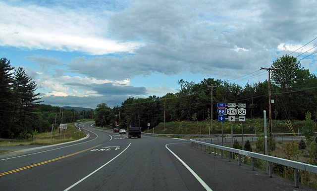
Southern terminus of
New York State Route 30A
at intersection two miles (3.2 km) north of
Schoharie, NY
, USA. View taken from
New York State Route 30
(NY 30) as it approaches intersection from the south; NY 30 continues north by turning right.
Southbound NY 30 comes into the intersection via a long downgrade, descending almost 500 vertical feet (150 m) in the mile (1.6 km) north of this intersection, requiring a stop sign. Until the late 2000s the intersection was more oblique and accidents frequently occurred when traffic on southbound NY 30 realized, too late, that they had to stop and traffic on northbound NY 30 and 30A did not. Heavy trucks have also been banned from using NY 30. Nevertheless, in October 2018 this became the site of a stretch limo crash that killed 20 people when the driver, coming in from the right, failed to stop at high speed and went into the parking lot whose entrance is seen at left, where the limo struck an SUV. Two pedestrians in the parking lot, as well as all in the limo, died. |
||
| Date | Taken on 25 June 2012, 08:16 | ||
| Source | New York State Route 30 | ||
| Author | Doug Kerr from Albany, NY, United States. Cropped and edited slightly by Daniel Case prior to upload | ||
|
Permission
( Reusing this file ) |
This file is licensed under the
Creative Commons
Attribution-Share Alike 2.0 Generic
license.
|
||
| Other versions | Unedited Flickr original |
| Camera location |
|
View this and other nearby images on: OpenStreetMap |
|
|---|
|
|
The
geographical information
in this file was retrospectively estimated.
The location may therefore be somewhat imprecise. Verifying and refining these coordinates is strongly encouraged. |