NASA_satellite_view_of_Southern_Ocean_phytoplankton_bloom_(crop).jpg

Size of this preview:
800 × 569 pixels
.
Other resolutions:
320 × 228 pixels
|
640 × 455 pixels
|
841 × 598 pixels
.
Summary
| Description |
English:
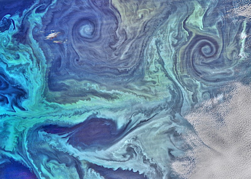
NASA satellite view of Southern Ocean phytoplankton bloom
On January 13, 2016, the Visible Infrared Imaging Radiometer Suite (VIIRS) on the Suomi NPP satellite captured this view of extensive phytoplankton blooms stretching from the tip of South America across to the Antarctic Peninsula. The image was built with data from the red, green, and blue wavelength bands on VIIRS, plus chlorophyll data. A series of image-processing steps highlighted the color differences and more subtle features, such as nearly a dozen eddies of varying sizes. |
| Date | |
| Source | Extracted from this Commons file |
| Author | NASA Suomi NPP satellite |
Licensing
This file is licensed under the
Creative Commons
Attribution-Share Alike 4.0 International
license.
-
You are free:
- to share – to copy, distribute and transmit the work
- to remix – to adapt the work
-
Under the following conditions:
- attribution – You must give appropriate credit, provide a link to the license, and indicate if changes were made. You may do so in any reasonable manner, but not in any way that suggests the licensor endorses you or your use.
- share alike – If you remix, transform, or build upon the material, you must distribute your contributions under the same or compatible license as the original.