Monument_Valley,_late_afternoon.jpg

Size of this preview:
800 × 452 pixels
.
Other resolutions:
320 × 181 pixels
|
640 × 362 pixels
|
1,024 × 579 pixels
|
1,280 × 724 pixels
|
3,008 × 1,701 pixels
.
Summary
| Description |
English:
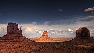
Monument Valley, the buttes are clearly stratified, with three principal layers. The lowest layer is Organ Rock Formation-(skirts, slope-former), the middle De Chelly Sandstone-(vertical cliffs) and the top layer is Moenkopi Formation (shales?, horizontal bedding) capped by Shinarump siltstone-(Shinarump Conglomerate-(locally)). The 3 buttes lie in Arizona, adjacent the Utah border. The
en:West and East Mitten Buttes
(left & center) are about 1.5 miles (2 km) apart. Merrick Butte is at photo-right.
日本語:
モニュメント・バレーの景観。アリゾナ州とユタ州の境に位置する特徴的なビュートのうちミトン (手袋) の形をしている西と東のミトン・ビュートは1.5 miles (2 km) 離れている (左、中央) 。右はメリック・ビュート。
|
| Date | |
| Source | Late afternoon |
| Author | Wolfgang Staudt from Saarbruecken, Germany |
Licensing
This file is licensed under the
Creative Commons
Attribution 2.0 Generic
license.
-
You are free:
- to share – to copy, distribute and transmit the work
- to remix – to adapt the work
-
Under the following conditions:
- attribution – You must give appropriate credit, provide a link to the license, and indicate if changes were made. You may do so in any reasonable manner, but not in any way that suggests the licensor endorses you or your use.
|
|
This image was originally posted to Flickr by Wolfgang Staudt at https://www.flickr.com/photos/53074617@N00/2197666743 . It was reviewed on 13 February 2008 by FlickreviewR and was confirmed to be licensed under the terms of the cc-by-2.0. |