Missouri,_Kansas_and_Texas_Railway_system_map_(1918).svg

Size of this PNG preview of this SVG file:
800 × 457 pixels
.
Other resolutions:
320 × 183 pixels
|
640 × 366 pixels
|
1,024 × 585 pixels
|
1,280 × 731 pixels
|
2,560 × 1,463 pixels
|
1,120 × 640 pixels
.
Summary
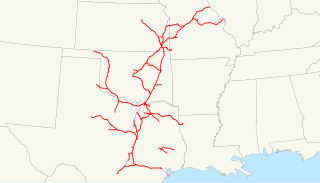
| Description | This is a map of the Missouri, Kansas and Texas Railway (Katy) as of 1918, with trackage rights in purple and then-proposed lines dotted. Email me if you would like a copy of the GIS data I created (modified from Bureau of Transportation Statistics North American Transportation Atlas Data) or if you see any errors. |
| Date | 1 October 2008 (original upload date) |
| Source | No machine-readable source provided. Own work assumed (based on copyright claims). |
| Author | No machine-readable author provided. NE2 assumed (based on copyright claims). |
Licensing
|
|
I, the copyright holder of this work, release this work into the
public domain
. This applies worldwide.
In some countries this may not be legally possible; if so: I grant anyone the right to use this work for any purpose , without any conditions, unless such conditions are required by law. |