Mirabelintlarptdiagram.png

Size of this preview:
800 × 526 pixels
.
Other resolutions:
320 × 210 pixels
|
640 × 420 pixels
|
1,024 × 673 pixels
|
1,280 × 841 pixels
|
1,979 × 1,300 pixels
.
Summary
| Description |
English:
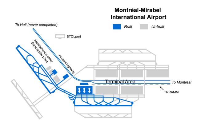
Diagram of Montréal-Mirabel International Airport Installations, built and unbuilt (the A-50 extension to Gatineau was completed in 2012)
|
| Date | 18 August 2005 (original upload date); 25 August 2005 (last version) |
| Source | Transferred from en.wikipedia to Commons. |
| Author |
AlbertR at English Wikipedia . Later version was uploaded by Andrewbot at en.wikipedia . |
| Other versions | Derivative works of this file: Mirabel airport diagram FR.png |
Licensing
|
|
This work has been released into the
public domain
by its author,
AlbertR
at
English Wikipedia
. This applies worldwide.
In some countries this may not be legally possible; if so: AlbertR grants anyone the right to use this work for any purpose , without any conditions, unless such conditions are required by law. |
Original upload log
The original description page was
here
. All following user names refer to en.wikipedia.
- 2005-08-25 00:05 Andrewbot 1979×1300× (50711 bytes)
- 2005-08-19 06:26 AlbertR 1979×1300× (165703 bytes)
- 2005-08-18 21:23 AlbertR 1979×1300× (164308 bytes) {{PD-self}}