Minimum_Safe_Altitude.gif
No higher resolution available.
Summary
| Description |
English:
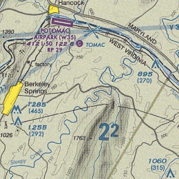
The representation of Minimum Safe Altitude (MSA) over an area, measured in feet above Mean Sea Level, look at 2
2
. This means that flying at or above 2200 ft all obstacles and peaks are safely avoidable even if pilot does not see them. Each chart section has its own MSA value.
|
| Date | |
| Source | Derived from File:Baltimore-Washington TAC 84.png |
| Author | Orion 8 |
Licensing
|
|
This image or file is a work of a
Federal Aviation Administration
employee, taken or made as part of that person's official duties. As a
work
of the
U.S. federal government
, the image is in the
public domain
in the United States.
|

|