Mare_Tyrrhenum_map.JPG
No higher resolution available.
Summary
| Description |
English:
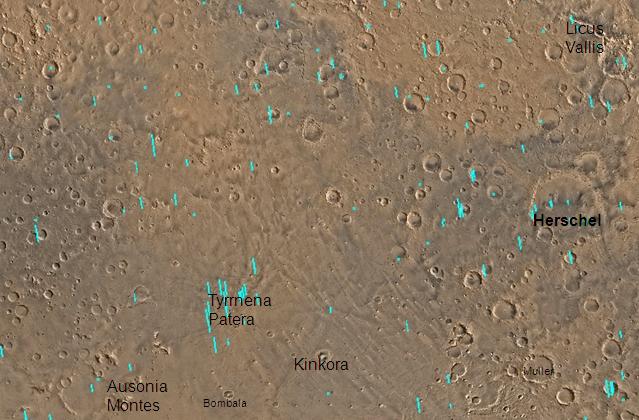
Map of Mare Tyrrhenum quadrangle with labels. The small, colored rectangles represent image footprints for the narrow angle camera on the Mars Global Surveyor. Some are about 1 mile wide, the others are about 2 miles wide.
|
| Date | |
| Source | http:www.msss.com/moc_gallery/s05-s10/mc22.html |
| Author | Jim Secosky ( Jimmarsmars at en.wikipedia ) modified NASA photo (U.S. Geological survey). |
Licensing
|
|
This file is in the public domain in the United States because it was solely created by NASA . NASA copyright policy states that "NASA material is not protected by copyright unless noted ". (See Template:PD-USGov , NASA copyright policy page or JPL Image Use Policy .) |
|

|
Warnings:
|
Original upload log
Transferred from en.wikipedia to Commons by Magnus Manske using CommonsHelper .
The original description page was
here
. All following user names refer to en.wikipedia.
- 2008-12-29 19:29 Jimmarsmars 639×420× (57864 bytes) {{Information |Description=Map of Mare Tyrrhenum |Source=http:www.msss.com/moc_gallery/s05-s10/mc22.html |Date=December 29, 2008 |Author=Jim Secosky modified NASA photo. |Permission= |other_versions= }}