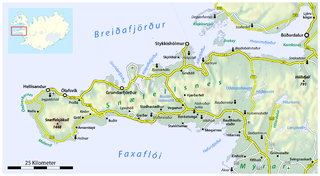
Map_of_the_Snæfellsnes_peninsula.png


Description
  • Deutsch: Karte der Halbinsel Snæfellsnes
  • English: Map of the Snæfellsnes peninsula
  • Français : Carte de la péninsule Snæfellsnes
Date
Source

own work, using

Author Maximilian Dörrbecker ( Chumwa )
Permission
( Reusing this file )

This map was created from OpenStreetMap project data, collected by the community.
This map may be incomplete, and may contain errors. Don't rely solely on it for navigation.

All OpenStreetMap data and maps are Creative Commons "CC-BY-SA 2.0" licensed
w:en:Creative Commons
attribution share alike
This file is licensed under the Creative Commons Attribution-Share Alike 2.0 Generic license.
You are free:
  • to share – to copy, distribute and transmit the work
  • to remix – to adapt the work
Under the following conditions:
  • attribution – You must give appropriate credit, provide a link to the license, and indicate if changes were made. You may do so in any reasonable manner, but not in any way that suggests the licensor endorses you or your use.
  • share alike – If you remix, transform, or build upon the material, you must distribute your contributions under the same or compatible license as the original.

Sie dürfen das Bild zu den folgenden Bedingungen nutzen:

  • Sie müssen den Namen des Autors nennen.
  • Im Falle einer Verbreitung müssen Sie anderen die Lizenzbedingungen, unter die dieses Bild fällt, mitteilen.
  • Sie müssen das Bild unter gleichen Bedingungen weitergeben. Wenn sie das Bild abändern oder Arbeiten auf diesem Bild aufbauen, müssen Sie das Ergebnis aus dieser Arbeit ebenfalls unter diese Lizenz stellen.
  • Jede dieser Bedingungen kann nach schriftlicher Einwilligung des Rechtsinhabers aufgehoben werden.

Captions

Add a one-line explanation of what this file represents

Items portrayed in this file

depicts

June 2009

image/png