Map_of_Indiana_highlighting_counties_presidentially_declared_disasters_June_2008.svg

Size of this PNG preview of this SVG file:
391 × 599 pixels
.
Other resolutions:
156 × 240 pixels
|
313 × 480 pixels
|
501 × 768 pixels
|
668 × 1,024 pixels
|
1,337 × 2,048 pixels
|
2,887 × 4,423 pixels
.
| Description |
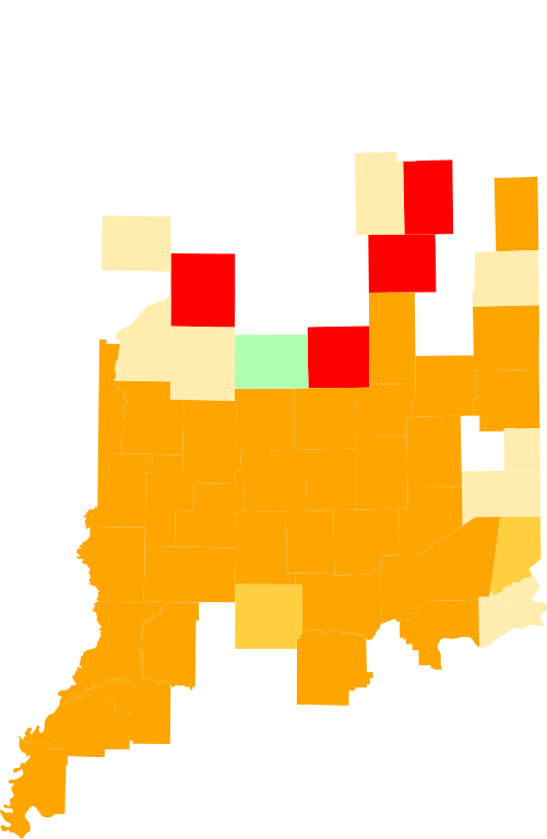
This is a locator map showing counties presidentially declared disasters for various types of assistance in Indiana for the flood of 2008.
FEMA map dated 08/08/08 -- 12:29 PM EDT
[1]
Public Assistance
Public and Individual Assistance
Individual Assistance
Public Assistance (Category B) limited to direct Federal assistance
Individual Assistance and Public Assistance (Category B) limited to direct Federal assistance
|
| Date | (UTC) |
| Source |
|
| Author |
|
|
|
This is a
retouched picture
, which means that it has been digitally altered from its original version. The original can be viewed here:
Map of Indiana highlighting Pike County.svg
:
|
I, the copyright holder of this work, hereby publish it under the following licenses:
This file is licensed under the
Creative Commons
Attribution-Share Alike 3.0 Unported
license.
-
You are free:
- to share – to copy, distribute and transmit the work
- to remix – to adapt the work
-
Under the following conditions:
- attribution – You must give appropriate credit, provide a link to the license, and indicate if changes were made. You may do so in any reasonable manner, but not in any way that suggests the licensor endorses you or your use.
- share alike – If you remix, transform, or build upon the material, you must distribute your contributions under the same or compatible license as the original.

|
Permission is granted to copy, distribute and/or modify this document under the terms of the GNU Free Documentation License , Version 1.2 or any later version published by the Free Software Foundation ; with no Invariant Sections, no Front-Cover Texts, and no Back-Cover Texts. A copy of the license is included in the section entitled GNU Free Documentation License . |
You may select the license of your choice.
Original upload log
This image is a derivative work of the following images:
-
Image:Map_of_Indiana_highlighting_Pike_County.svg
licensed with PD-self
- 2006-02-12T12:14:52Z David Benbennick 5350x3504 (44178 Bytes) {{subst:User:Dbenbenn/clm|county=Pike County|state=Indiana}}
Uploaded with derivativeFX