Map_Israel_Judea_926_BC-fr.svg

Size of this PNG preview of this SVG file:
362 × 600 pixels
.
Other resolutions:
145 × 240 pixels
|
289 × 480 pixels
|
463 × 768 pixels
|
618 × 1,024 pixels
|
1,236 × 2,048 pixels
|
554 × 918 pixels
.
| Description |
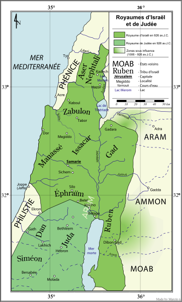
English:
Kingdoms of Israel and Judea (Near east) in 926 BC.
Français :
Royaumes d'Israël et de Judée en 926 av. J.-C.
|
| Date | (original file); 2007-04-19 (French translation) |
| Source | Own work (based on Wielki Atlas Historyczny , Demart publisher, 2004, ISBN 8373911030 ). Image translated from Image:Map Israel Judea 926 BC-pl.svg and renamed from Image:Israel-Judea-Kingdoms-fr.svg |
| Author | Marcin n ® ☼ (original file); Kimdime69 (French translation) |
|
Permission
( Reusing this file ) |
This file is licensed under the
Creative Commons
Attribution-Share Alike 2.5 Generic
license.
|
| Other versions |
[
]
|


|
This SVG file contains embedded text that can be translated into your language, using any capable SVG editor, text editor or the SVG Translate tool . For more information see: About translating SVG files . |
Atlas
This map should be added to the Wikimedia Atlas .